How Coastal Erosion Challenges an Ancient Continent
Think of your favorite place in the world.
Now imagine I told you that soon, that place would disappear off the face of the earth. This alarming news is exactly what I read as a child about my favorite place in the world: Cape Cod, MA. This coastal region and tourist attraction is where I have spent a vacation every year of my life. One year, I bought a book about the coastal scenery of the Cape and was distraught when I read in the opening pages that the ruthless Atlantic ocean is eroding away at the sandy beaches and cliffs of Massachusetts’ coast at an alarming rate. The entire peninsula will not be there forever. Thankfully, my own personal future vacations have nothing to fear, but the same cannot be said for people looking for a vacation just a few thousand years from now, which is, geologically speaking, not so far away.
The views expressed in this article reflect those of the author, and not necessarily those of New Creation.
In 2025, I took off for the Cape in early September, just outside of the Cape’s summer season. School was back in session, the weather was still warm, and the beaches were free; a solitary coast awaited me. But as I journeyed from place to place, I noticed an abundance of evidence for coastal erosion and realized how powerful of a case this erosion is for a young North American continent. Though I am no geologist, the clear evidence of erosion on the wild Northeast coast speaks for itself. It does not take a geology expert to recognize such dramatic geological processes. Let me take you through the beautiful New England coast and share why, in all likelihood, it has not been here for hundreds of millions of years.
The Evidence
Below is a summary of features and landmarks that show rapid erosion in the Cape Cod region. It is a very well-documented process, but the physical telltale signs of erosion are fascinating.
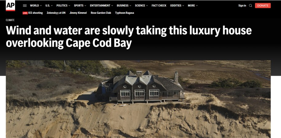
Sandy Cliffs
The highlight of Cape Cod is the Nationally protected 40-mile stretch of beaches and dunes known as the Cape Cod National Seashore. While I usually go to the southeastern beaches in Chatham, MA, this time I treated myself by driving a little longer than usual to make it all the way up to Coast Guard Beach in Eastham. There, I found Cape Cod’s famous sandy cliffs stretching north and south. Even as I stood on the beach and watched, I could see sand falling down the cliffs. I can only imagine how destructive the ocean would be when the waters rise or when a coastal storm hits the sandy cliffs.
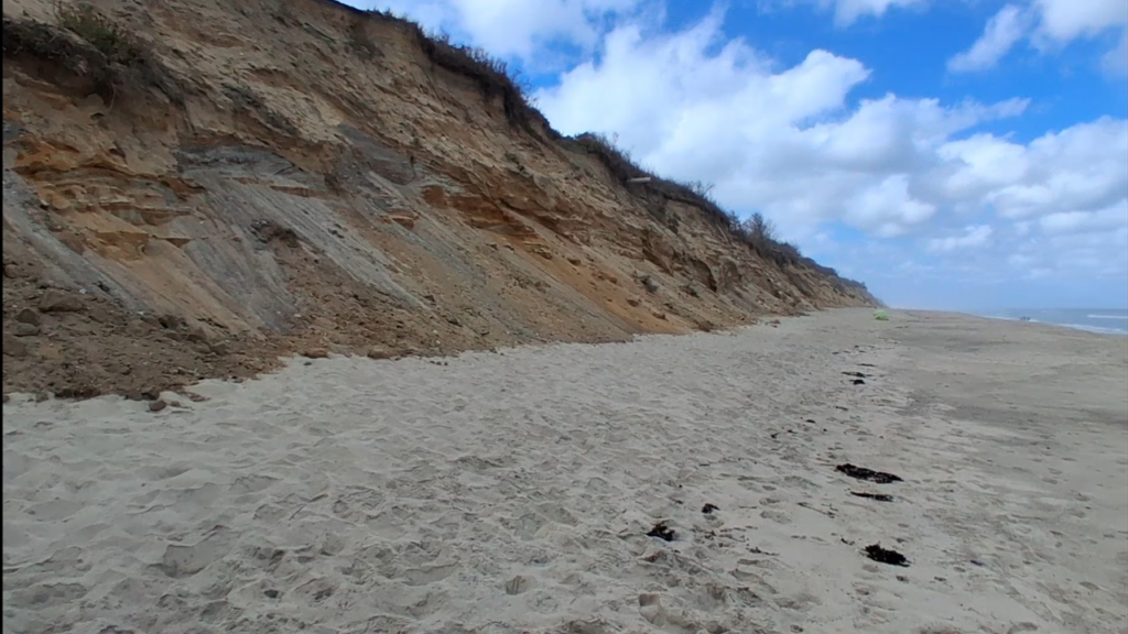
Signs erected at the beach describe how the cliffs are eroded about 3 feet every year, making the Cape Cod beaches a vanishing coastal landmark. These signs document the history of these dynamic shores, and following these signs led me to the next piece of evidence.
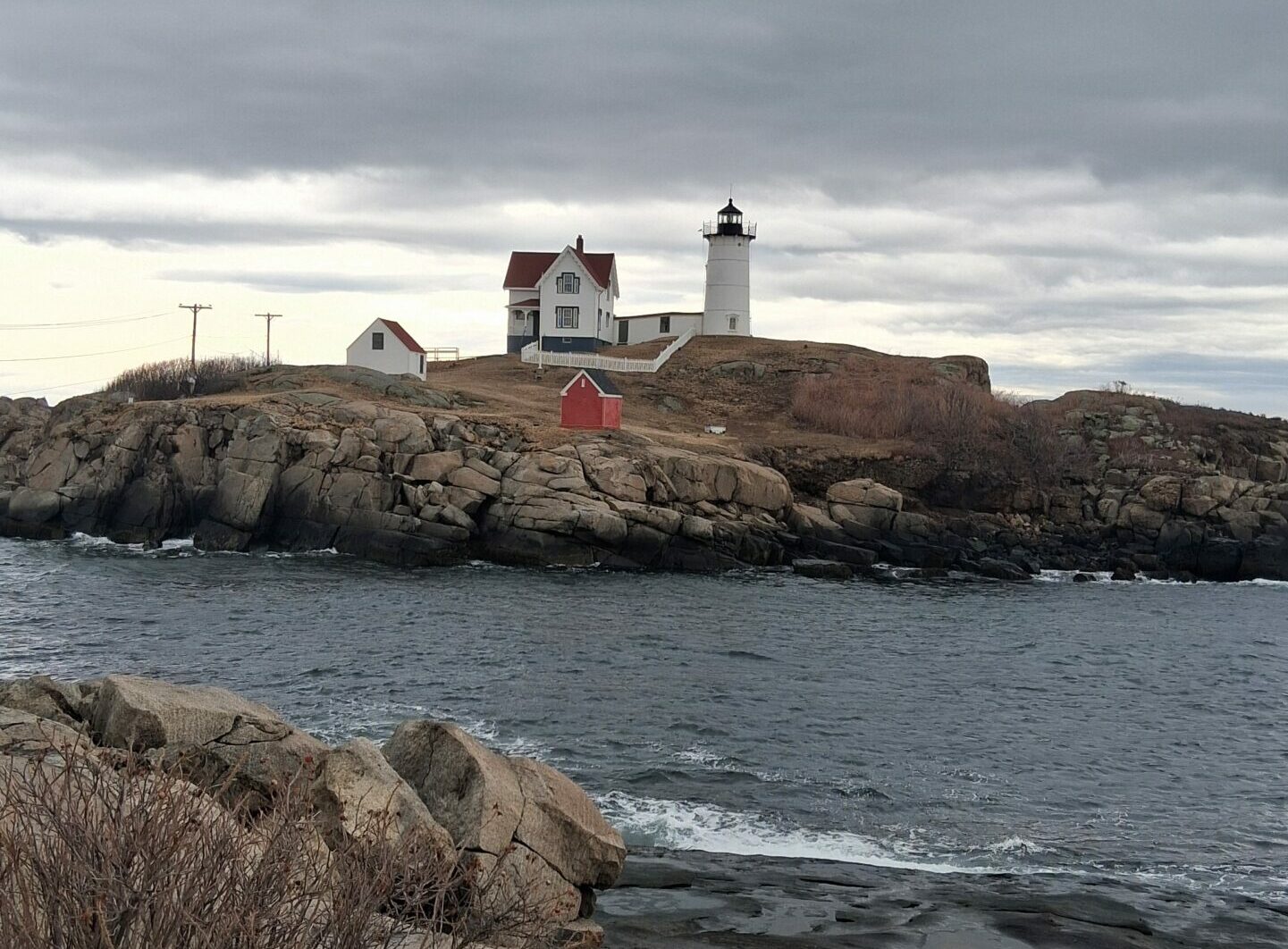
Leaping Lighthouses!
Nauset lighthouse sits just north of Coast Guard Beach (a fork in the road will bring you to either one). Upon visiting Nauset lighthouse, I read all about how the lighthouse has been moved four times, by necessity, for a total of 600 feet traveled. All of this occurred in the years since its erection in the 1830s.
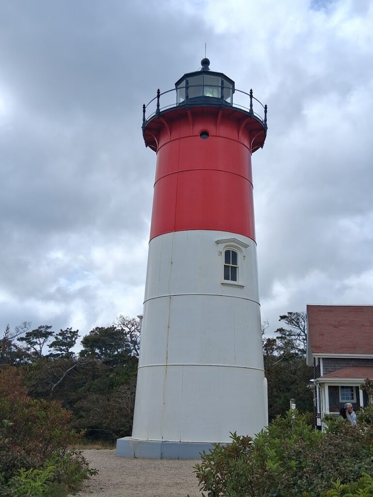
The last time Nauset lighthouse had to be moved was in 1993. At the time, the ocean was only 40 feet away. The cliffs had receded due to the advance of the Atlantic. It now resides a couple hundred feet from the crashing waves. In just a few decades, it will have to be moved again.
To move such a structure, a local construction company will raise the lighthouse enough to slide a platform underneath the base. In a surprisingly long process, the platform is slowly carried inland until it is safe from the sea but close enough to be seen from seagoing vessels. What is an incredible feat of human ingenuity is also a powerful demonstration of how powerful coastal erosion is. How could a continent last for hundreds of millions of years while subjected to such a geological phenomena?
Drowning Trees
I could not escape erosion no matter how far down the coast I traveled. Visiting Monomoy National Wildlife Refuge was a dream come true. This beautiful paradise sits at the very southern tip of Cape Cod; the elbow, you might say. While exploring the refuge, I stumbled on a hidden beach that, upon further observation, should not be a beach at all.
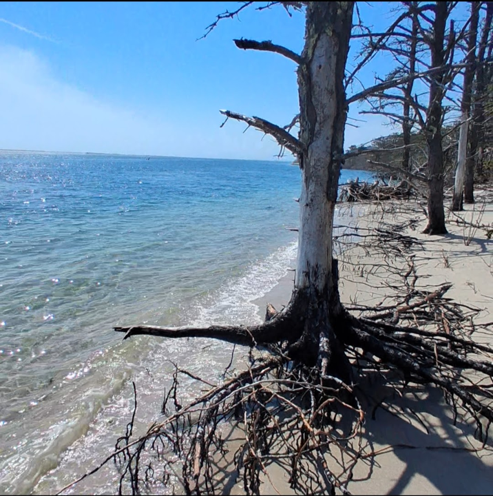
I was standing in a forest, with a beach infringing on it. Instead of soil and tall, healthy trees, the long tree roots were uprooted and exposed. Seawater had removed the sand from the beach, leaving mangled trunks and exposed roots. Investigating further, I found dead tree bottoms with long root systems farther down the beach, where the ocean had dropped them off after sweeping them out to sea. My visit was in the middle of this destructive process, so I could see trees in every possible state: healthy trees in good soil further inland, dead trees with exposed roots on the very edge of land, and rotting trunks swept away from the beach, having succumbed to the unstoppable sea.
Clearly, no one cared to move these trees inland as they do to the Nauset lighthouse. So, in this case, we get to see what happens when erosion goes unchecked. One year from now, this tree will be even closer to being driftwood.
Evaluating the Evidence
Now that we see evidence of rapid erosion, it is time to assess what this means for the history of the continent. As a creationist, I saw these landmarks as real, physical evidence that the continent cannot be hundreds of millions of years old. But there is more to the story. How do we know where erosion began? How much erosion has taken place? Can other processes make up for erosion and stabilize the landmass? Let’s take a look.
Is the Rate of Erosion too fast for Deep Time?
The rate of erosion at 3 feet per year, is remarkably fast. North America is only about 2,800 miles wide from coast to coast, with the maximum land distance reaching 5,000 miles. Convert 2,800 miles to feet, and one can easily estimate how long it would take to erode all of North America. The number you should come up with is about 5 million years. That calculation, of course, does not take into account the different types of rock that exist throughout the continent, which vary in their susceptibility to erosion. Nor does it account for any other forces other than erosion. But it also happens to be a blink of the eye in Deep Time.
To put this in perspective, the continent of North America supposedly broke away from Pangea about 200 million years ago. According to conventional plate tectonics, it has been drifting and eroding for all of that time. Based on these numbers alone, it should have eroded away forty times over! It is safe, then, to claim that today’s erosion rates are too fast for deep time.
But where did the erosion begin?
Of course, we need to know where erosion began to truly calculate whether North America should still be here. Common sense tells us it is highly improbable that North America was once forty times larger than it is today. But it is nevertheless important data to discover where erosion began, to see whether erosion rates fit into a young-earth timeline.
So, how do we know where erosion began when the sediment that has already eroded is gone? Well, the sand from the beaches may be shrinking, but the continent itself is not actually shrinking. When beachgoers step into the ocean for a Summer swim, they do not actually leave the continent. The continental floor of North America continues out into the ocean, dropping off where the ocean floor begins miles past the visible coast. Google earth images show clearly where the continents begin under the water, as well as where the coast begins above sea level.
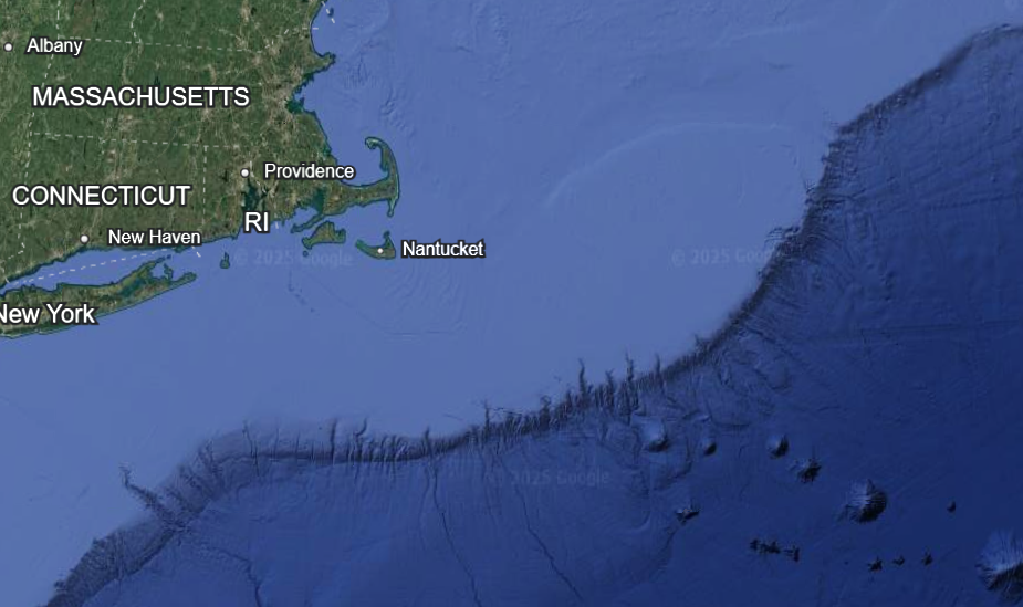
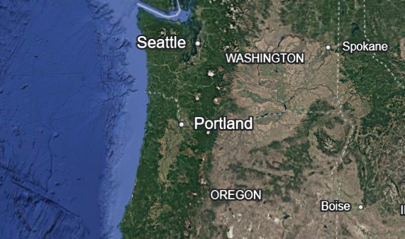
Take another look at the picture of Southern New England above. The light blue color shows how far the North American continent extends into the ocean. Then, it reaches a sea shelf and drops off suddenly. The edge of the light blue is where erosion must have begun, and the Atlantic ocean has eroded away at the land until its current state. The west coast has much less evidence of erosion. Compare the photo of the Northeast to this photo of the West coast. The light blue color does not extend nearly as far west, meaning much less erosion has occurred in the west coast. We can attribute this difference to several factors, such as more tectonic activity in the west (earthquakes push the sea back) and the mountain ranges in the northwest being more resistant to erosion than the softer sediments in the east.
Explanations for Erosion
So far, we have established that erosion is happening throughout our sandy coasts, and that the rate of erosion is so fast North America should have completely eroded away roughly 195 million years ago. But before we declare that erosion contradicts the old earth theory, we should consider whether other geological processes can offset the erosion and stabilize the continent. Though critical thinking is a must in science, we must not be so critical as to disregard theories prematurely. So, are there any known geological processes that can slow or counteract erosion? There are two proposed mechanisms for this: deposition and continental uplift. We will define and evaluate each one.
Accretion
Accretion is simply the opposite of coastal erosion. Forces lay down material on the coasts of a continent instead of removing it. Surveys done on the world’s coasts reveal that accretion is also a prevalent process. So, one explanation for the continued existence of the North American continent is that accretion offsets the erosion. Sediment that erodes in one place ends up deposited elsewhere in the world, thus allowing continents to last hundreds millions of years.
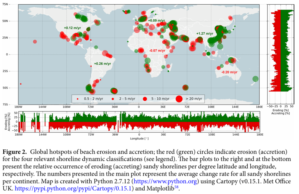
An excellent depiction of this phenomena comes from the paper “The State of the World’s Beaches,” a Scientific Report from the journal Nature. The image above shows areas of beach erosion (in red) compared to accretion (in green). The survey does not show all coasts because not all coasts are sandy beaches. From a bird’s eye view, it seems like accretion is just as abundant as erosion—maybe even more abundant! The suggested interpretation from the literature is that the world is stable: the ocean takes sand from some coasts, but then adds sand to other coasts. Has this solved the erosion problem for conventional geology?
A Question of Stability
The report on the world’s beaches found that 28% of the world’s sandy beaches currently experience accretion, compared to 24% experiencing erosion. But this is not the whole story. The region of most accretion is the coast of eastern Asia, which looks like a giant blob of green in the map. But in this case, dramatic human activity is the cause of accretion. This means that it is not relocated sediment from erosion but rather new accretion deposited anthropogenically. Even if this helps keep the continent stable, in the conventional theory, the human species has not been around for a long time, and so it is a mystery how accretion would have happened along this coast without the contribution of human activity. Without the human imprint, it is questionable that the world’s accretion would outpace the world’s erosion.
In addition to this problem, we can also notice certain patterns in the world’s accretion beyond human activity. Most of the accretion occurs near river deltas. A river delta is where a river meets the sea, not only dumping water into the ocean but also depositing sediment carried from further inland. For example, four rivers in North America empty into Hudson’s Bay in northern Canada. The Mississippi and Rio Grande rivers dump sediment into the Gulf of America, accounting for the green colors in the southern states.
In short, accretion is not part of an interworking system of moving sediment. Instead, it reveals an unstable pattern where coastal erosion eats away at the continents while accretion adds sediment only to river deltas. This would not keep continents stable but would lead to continued destruction of continents over time. This is why experts continue to believe Cape Cod is going under, even though some areas of the Cape do experience accretion. It is not a question of which process occurs more. It is a question of whether both processes occur in a way that keeps the world’s continents stable. The answer seems to be a resounding no.
Continental Uplift
The other response to the problem of erosion is a tectonic one. The basic idea is that tectonic plates lift the continent up over time, exposing more land to replace the eroded cliffs. Relative to sea level, if a continent rises, the new surface of the continent “pushes” the sea back, countering the oncoming ocean.
As an example, take the continental plates in western America. In the Pacific Northwest, the Pacific plate is continuously sliding under the North American plate, causing many geological phenomena (such as the famous Mt. St. Helens eruption). This suggests that there could be a stable cycle keeping continents from eroding too quickly. Instead of erosion and accretion, another option could be erosion and continental uplift. In this scenario, erosion cuts through the crust for a few thousand years, before the continent rises up. The uplift exposes new crust that pushes the coast back farther. When that crust is eroded, the continent rises again, exposing more crust and pushing the beach back once more.
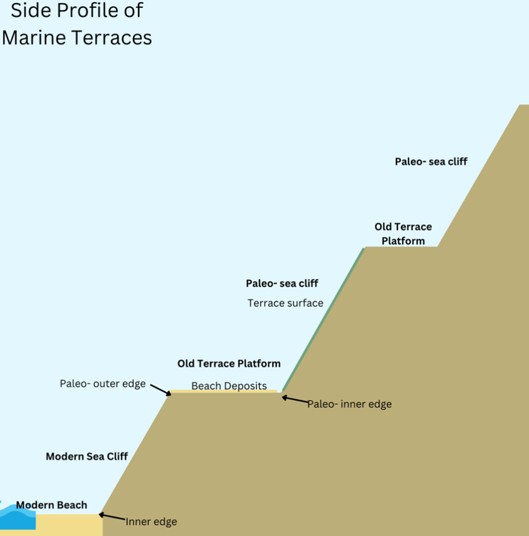
This cycle of continental uplift forms a geological formation called a marine terrace. Essentially, when the continent lifts and then erodes and then lifts again, the coast becomes a series of steps. On the west coast, several of these terraces can be found, showing evidence of hundreds of thousands of years of cyclical erosion and drops in sea level. Does this solve the problem of coastal erosion for deep time?
A Question of Speed
Once again, the speed of coastal erosion gets the last laugh. The rate of erosion is so quick, that it would take many, many cycles of erosion and uplift for the continent to remain stable for millions of years. Geologist Monte Fleming evaluated the data for the continental uplift theory and found that the crust would have to be raised 50 kilometers in order to combat the erosion. This seems wildly improbable, considering the entire crust of the earth is only 20 kilometers deep!
It gets worse for the conventional paradigm if we look at the east coast, which erodes even faster. The east coast would require 400 kilometers to keep the coast where it is today. To put this in perspective, if the continent was 400 kilometers higher than sea level today (which is where it would have to be at the beginning in order for it to be at the level it is now), it would be the same height above sea level as the International Space Station!
In addition to these mathematical challenges, the currently observed rate of continental uplift is faster than this explanation requires. If continental uplift occurred at currently observed speeds, it would rise too quickly to explain the coastal evidence we see today.
What about the Erosion and Uplift we do see?
Remember, we do observe evidence that hundreds of thousands of years of erosion occurred, if we assume today’s observed rates. Even if millions of years is not plausible under current conditions, how do we explain this evidence in just a few thousand years?
Well, dramatic geological events can cause lots of erosion in a short period of time. If instead of slow continental drift over millions of years we assume a catastrophic continental “sprint” in just a few thousand years, it makes sense that the same catastrophe that sent these continents running might also have eroded the coasts far more rapidly than they do today.
Remember, creationists view the continents as the result of previous dramatic catastrophes. These catastrophes are only moving slowly today because they are in recovery from more dramatic moments in the past. We do not assume present geological rates are always constant, because we know dramatic catastrophes can change these rates. And we have reason to believe such events did occur, on a scale never considered possible by conventional scientific models. In other words, if we see evidence of continental sprints, fast fossilization, and rapid sediment deposits, it is natural to also expect lots of erosion!
In the End: Erosion is A Nuanced Problem for Deep Time
Erosion continues to challenge the conventional understanding of the history of our continents. Two explanations attempt to solve the problem. While there is technically enough accretion to account for erosion, it does not have a cyclical or stable relationship with erosion. Continental uplift, by contrast, does have a cyclical relationship with erosion. But the rate of erosion is so fast, too many cycles would be required to explain the current state of things. There is sparse evidence that many cycles of uplift and erosion occurred in the earth’s past, and the amount of eroded crust needed to explain away the problem is nothing short of astronomical. At no point in earth’s history could the continents have been 50 kilometers high, and there is no conceivable way at present to explain how continents could have reformed themselves over and over again.
This discussion shows the importance of doing thorough research and looking deeply into a scientific question. At first glance, erosion looks like a death blow to deep time and ancient dates given to continents. But two scientific hypotheses appear to explain away the challenges with equal ease. Only by taking a thorough look into both of these explanations, and following both arguments closely, can creationists come to terms with the data. If creationists such as Monte Fleming had never actually considered the hypotheses presented, it would be too easy for conventional scientists to dismiss the challenges of creationists. At the end of the day, only a deeper, nuanced approach yields good, thorough results. And in this case, the results once again reflect the historicity of the Bible.
Footnotes
Luijendijk, A., Hagenaars, G., Ranasinghe, R., Baart, F., Donchyts, G., & Aarninkhof, S. (2018). The state of the world’s beaches. Scientific reports, 8(1), 6641.
Learn More
Let’s Talk Creation podcast: Erosion Shows the Earth is Young!: https://youtu.be/wz5CVYi9yXc?si=ugcpsxdr7XAhzRrd