Editor’s Note: Last updated on May 30, 2022
One of the most hotly-debated topics within young-earth creationism is which layers of the geologic column represent those formed during Noah’s Flood. In our quest to resolve this disagreement, it is common for creationists to identify a single point on the geologic column where the Flood begins or ends. This is problematic, however, because what most people think of as the geologic column does not reflect what is actually observed in the field.
We can compare the geologic column as seen in geology textbooks to a national park field guide. The field guide contains a diverse array of species that should exist in the national park. However, you are unlikely to see all of these species while you are there. Likewise, the geologic column is our field guide to the earth’s rock record. It tells us which rock layers should appear above or below other rock layers. However, there are no places on the earth where you will see the geologic column as diagrammed in textbooks.
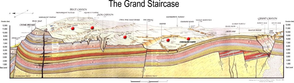
If we are to find Noah’s Flood in the geologic record, we should apply our search to a real-world location where much of it can be found. Our destination of choice? The Grand Staircase of Arizona and Utah. Here, the layers that compose the Staircase are visible primarily in three national parks: Grand Canyon National Park, Zion National Park, and Bryce Canyon National Park.
Grand Canyon National Park

The Grand Canyon in Arizona contains layers from the Precambrian and Paleozoic. The Precambrian layers contain fossils that most geologists think are evidence of bacterial colonies, called stromatolites. Fossils of shallow marine invertebrates, including trilobites and brachiopods, characterize the lower Paleozoic layers. These are the Tapeats Sandstone, Bright Angel Shale and Muav Limestone. In the Temple Butte Limestone and Redwall Limestone specifically, the marine invertebrates are joined by fossils of fish, sea lilies, and shelled, squid-like animals called nautiloids.

The first fossils of land plants, insects, and trackways of amphibian or reptile-like critters finally first appear within the Supai Group, Hermit Shale, and Coconino Sandstone. However, we find no body fossils of land-dwelling vertebrates in these layers. The uppermost layers of the Grand Canyon—the Toroweap Formation and the Kaibab Limestone—contain fossils of marine organisms. For example, nautiloids, bryozoans, sponges, trilobites, brachiopods, and corals. Note that the fossil sequence at the Grand Canyon, with notable exceptions, largely reflects that of a sea-to-land trend.
Click here for more information on fossils found in the Grand Canyon.
Zion National Park

The sequence continues further north with layers from the Mesozoic, exposed in Zion National Park. After the reappearance of the Kaibab Limestone is the Moenkopi Formation above it. It displays no body fossils, but plenty of reptile and amphibian footprints.

The Chinle Formation marks the appearance of the first land-dwelling vertebrate body fossils. Here, we find crocodile-like reptiles called phytosaurs and aetosaurs, and large amphibians such as Metoposaurus. The Moenave, Kayenta, and Navajo formations are sandstones that contain freshwater fish, plants, and numerous theropod tracks. Finally, the topmost layers here belong to the Carmel Formation, known for its marine fossils, like crinoids, clams, and corals.
For more information on fossils found in Zion National Park, click here.
Bryce Canyon National Park

We finally arrive at Bryce Canyon National Park, even further north. The Navajo Sandstone and Carmel Formation show up once again, followed by the Entrada Formation and the Dakota Formation. They are known for their dinosaur and pterosaur footprints. The Trophic Shale contains fossils of sharks, marine reptiles, and nautiloids.
Meanwhile, we find a variety of fossils throughout the Straight Cliffs Formation, Wahweap Formation, and Kaiparowits Formation. These include land plants, marsupials, frogs, lizards, and dinosaurs like duck-billed hadrosaurs, tyrannosaurs, and ceratopsians (horned dinosaurs). At the very top, we have the Canaan Peak Formation and the Claron Formation. Here, we find fossils of flowering plants, lizards, marsupials, fish, crocodiles, and frogs.
Click here for more on the fossils found in Bryce Canyon.
On Top of the Stairs
Last but not least, let’s discuss the fossils found in the topmost layer of sediment of the entire Staircase area. We find these fossils in areas eroded after the layers described above formed, but before more sediment accumulated. These include freshwater mollusks, bison, and bighorn sheep in Zion Canyon. In the Grand Canyon, it even includes ground sloth bones and droppings found in caves. For more on these recent fossils, click here and here.

So, how does each of the Flood boundaries listed above appear in the geologic record at the Grand Staircase? Below, we will discuss different Flood boundary models in relation to this area. Please note that the models listed below are generalizations and do not reflect all variations of opinions.
Flood Boundary Models Applied to the Grand Staircase
As you study these four views and seek to determine the truth of the matter, remember that the first step is to study the Bible in order to properly understand the chronology of the Flood. Next you must correlate biblical history with geographical history. This requires a careful study of widespread geologic layers. Finally, you should use the information you have gathered to determine which Flood model is the most parsimonious. In other words, try to find the Flood model that is the simplest scientific explanation that best fits the data we currently have at hand.
Upper Cenozoic Boundary Model
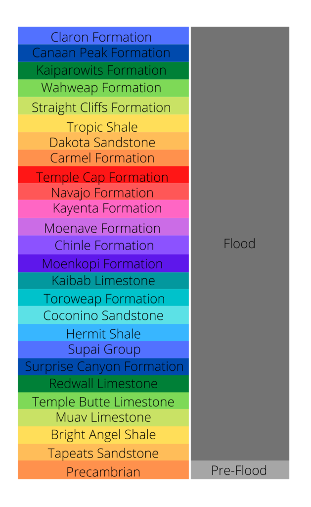
The Upper Cenozoic Boundary Model argues that most geologic activity in Earth’s history took place during the Flood. As such, virtually all of the Grand Staircase is the product of the Flood.
There is much discussion regarding the location of the pre-Flood/Flood boundary among those who accept this model. Some consider the Precambrian—everything below the Great Unconformity—to have formed during Creation Week. Others, however, believe some or much of the Precambrian formed early during the Flood.
The primary explanation for the order of fossils in the Grand Staircase according to this model is Ecological Zonation Theory. In other words, the order reflects the order in which the Flood swept away, transported, and buried pre-Flood organisms. Marine lifeforms of the Tapeats Sandstone, Bright Angel Shale and Muav Limestone were the first to be buried. We/scientists believe they inhabited the large, inland seas that covered much of the United States (including the Grand Staircase region) before the Flood.
The Temple Butte Limestone, Redwall Limestone, Supai Group, Hermit Shale, Coconino Sandstone, Toroweap Formation, and Kaibab Limestone reflect coastal lifeforms that the Flood transported and buried here. Many fossils did not live where we find them preserved today. This includes dinosaurs, other land creatures, and plants found in the layers of Zion Canyon and Bryce Canyon. They lived in the lowland region called the Dinosaur Peninsula, which ran from modern-day Minnesota to New Mexico. The rising floodwaters swept them away from there and buried them in what is now the Grand Staircase region.
Finally, there are the flowering plants, certain mammals, fish, crocodiles and other organisms of the Canaan Peak Formation and the Claron Formation. These lifeforms did not live with the dinosaurs. Rather, they originally lived in upland regions of the pre-Flood world. They were probably located in what is now Canada. Their burial in the Grand Staircase region occurred in the second half of the Flood, when the waters receded from the land. Movements of the earth’s crust uplifted the entire region, and receding floodwaters eroded much of the region away. This exposed the layers for our viewing today.
The most recent fossils of mammals, birds, and other lifeforms date from the brief ice age that followed the Flood. High levels of rainfall in the region fed massive lakes and caused greater plant growth in the area than today. This provided food and water sources for post-Flood ground sloths and other animals in the Grand Canyon, and bighorn sheep, bison, birds, and other creatures in the lakes of Zion Canyon.
In Support of this Position:
Clarey, T.L., and D.J. Werner. 2018. “Use of sedimentary megasequences to re-create pre-Flood geography.” In the Proceedings of the Eighth International Conference on Creationism, ed. J.H. Whitmore, pp. 351–372. Pittsburgh, Pennsylvania: Creation Science Fellowship.
Clarey, T.L., and D.J. Werner. 2019. “Compelling Evidence for an Upper Cenozoic Flood/Post-Flood Boundary: Paleogene and Neogene Marine Strata that Completely Surround Turkey.” Creation Research Society Quarterly 56:68-75.
Holt, R. D. 1996. “Evidence for a Late Cainozoic Flood/post-Flood boundary.” CEN Tech. J., 10(1): 128-167.
Oard, M.J. 2007. “Defining the Flood/post-Flood boundary in sedimentary rocks.” Journal of Creation 21(1):98–110.
Against this Position:
Arment, C. 2020. “Implications of Creation Biology for a Neogene-Quaternary Flood/Post-Flood Boundary.” Answers Research Journal, 13, 241-256.
Johnston, Richard H. 1997. “THE FLOOD/POST-FLOOD BOUNDARY.” Creation Ex Nihilo Technical Journal, vol. 11, no. 2, pp. 162–165.
Ross, M.R. 2012. “Evaluating potential post-Flood boundaries with biostratigraphy—the Pliocene/Pleistocene boundary.” Journal of Creation 26(2):82–87.
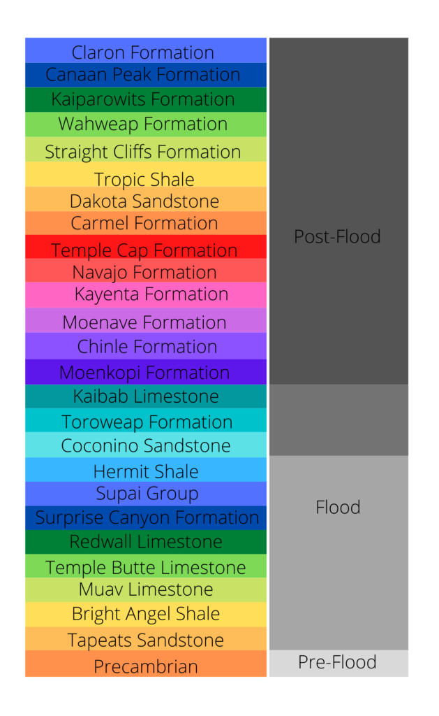
Upper Mesozoic-Lower Cenozoic Model
The Upper Mesozoic-Lower Cenozoic Model posits that the thick, uniform packages of sediment that carpet the Grand Staircase region are the result of the global Flood. Meanwhile, these large-scale deposits disappear in the Cenozoic layers of Bryce Canyon. They are replaced by deposits formed locally or in basins. As a result, advocates of this model place the Flood/post-Flood boundary between the Kaiparowits Formation and the Canaan Peaks Formation. This roughly coincides with the Cretaceous-Paleogene (K-Pg) boundary which gives this model its more popular name, the K-Pg Boundary Model. However, this is more of a misnomer, as a number of geologists who accept this model place the boundary a little higher in the Cenozoic in other regions of the world.
This model bears several things in common with the one described above. Like the Upper Cenozoic Boundary Model, many who hold to the Mesozoic-Cenozoic Model think that the majority of the Precambrian formed during Creation Week. In addition, it also explains the order of fossils in much the same way, with Ecological Zonation Theory. Many Paleozoic marine lifeforms may have been buried close to where they were originally living. The land lifeforms buried in layers on top of them, however, were likely transported great distances from somewhere west of the Rocky Mountains. Pre-Flood dinosaurs and other Mesozoic land animals lived the remainder of their days on temporarily exposed tidal flats until the floodwaters overwhelmed them for good by Day 150 of the Flood. This is where they left footprints and droppings, and made nests and laid eggs.
The primary difference between this model and the former concerns the Cenozoic. According to this model, the Flood’s contribution is that of the Paleozoic and Mesozoic rocks. Meanwhile the Cenozoic formed after the Flood. Advocates of this model point out that there is a trend from large-scale Flood layers of the Kaiparowits Formation to the post-Flood layers of the Canaan Peaks Formation, which were largely formed in basins. The Canaan Peaks Formation and Claron Formation represent deposits formed in post-Flood lakes. There was much geologic activity after the Flood in this region. Large-scale natural disasters that were still at play in the decades or centuries after the Flood further reshaped the region. Following this was a brief Ice Age lasting for hundreds of years.
In Support of this Position:
Arment, C. 2020. “To the Ark, and Back Again? Using the Marsupial Fossil Record to Investigate the Post-Flood Boundary.” Answers Research Journal 13:1–22.
Austin, S.A., Baumgardner, J.R., Humphreys, D.R., Snelling, A.A., Vardiman, L. and Wise, K.P. 1994. “Catastrophic plate tectonics: a global Flood model of Earth history” in: Walsh, R.E. (Ed.), Proceedings of the Third International Conference on Creationism, Technical Symposium Sessions, Creation Science Fellowship, Pittsburgh, pp. 609–621.
Chadwick, A.V. 2000. “Megatrends in North American paleocurrents.”
Ross, M.R. 2012. “Evaluating potential post-Flood boundaries with biostratigraphy—the Pliocene/Pleistocene boundary.” Journal of Creation 26(2):82–87.
Whitmore, J. and Garner, P. 2008. “Using suites of criteria to recognize pre-Flood, Flood, and post-Flood strata in the rock record with application to Wyoming (USA).” In: Snelling, A.A. (Ed.), Proceedings of the Sixth International Conference on Creationism, Creation Science Fellowship, Pittsburgh, PA, and Institute for Creation Research, Dallas, TX, pp. 425–448.
Whitmore, John H. and Wise, Kurt P. 2008. “Rapid and Early Post-Flood Mammalian Diversification Evidenced in the Green River Formation.” Proceedings of the International Conference on Creationism: Vol. 6 , Article 36.
Against this Position:
Baumgardner, J. 28 June 2021. “The Dawning of Catastrophic Plate Tectonics.” International Conference on Creationism, Reflections.
Clarey, T.L. 2017. “Local catastrophes or receding Floodwater? Global geologic data that refute a K-Pg (K-T) Flood/post-Flood boundary.” Creation Research Society Quarterly 54(2):100–120.
Oard, M.J. 2013. “Geology indicates the terrestrial Flood/post-Flood boundary is mostly in the Late Cenozoic.” Journal of Creation 27(1):119–127.
Walker, T. 2014. “Post-Flood boundary—a robust analysis flawed by hidden assumptions. Journal of Creation 28(2):60–61.
Models Using Recolonization Theory
Recolonization Theory suggests that a considerable portion of the geologic record formed after the Flood. Many (though certainly not all) young-earth geologists in the Netherlands and other parts of Europe espouse it, earning it the nickname European Flood Model. It gets its name from the idea that much of the fossil record formed after the Flood, as lifeforms were recolonizing the earth.
Advocates of Recolonization Theory (called “recolonizers”) come in two flavors: those who place the Flood/post-Flood boundary in the upper Paleozoic, and those who place it within the Precambrian. Some, like David Tyler’s version of Recolonization Theory, also place the beginning of the Flood within the Precambrian and the end of the Flood in the mid-Paleozoic.
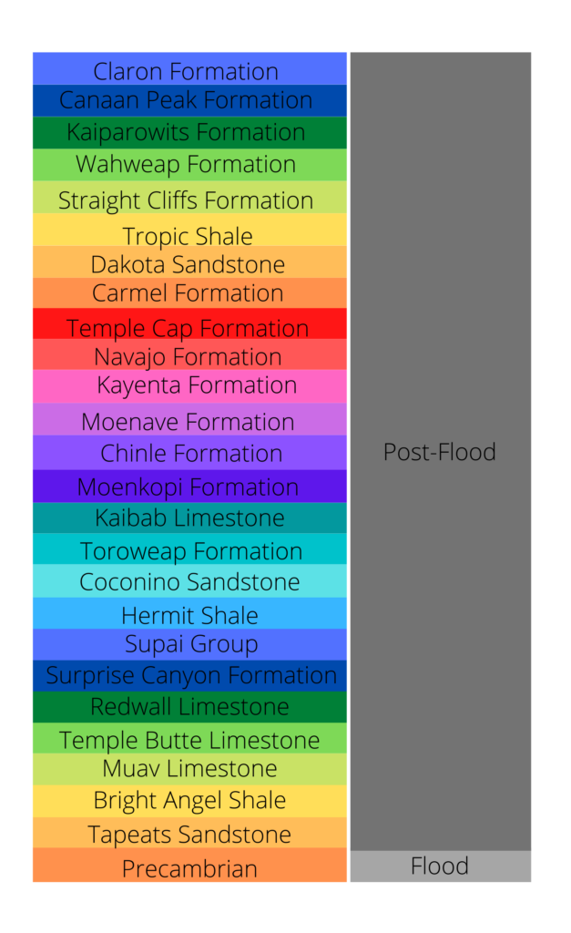
Upper Paleozoic Boundary Model
The Upper Paleozoic Boundary Model suggests that the Flood is responsible for the thick packages of marine sediments and fossils blanketing the continents. Notably, these layers are below those that contain traces left behind by living land animals, like footprints, droppings, nests, eggs, or burrows. In the Grand Staircase, this places the Flood/post-Flood boundary somewhere between the Coconino Sandstone and the Moenkopi Formation.
While some Upper Paleozoic recolonizers would include the Precambrian in Flood deposits, others place the beginning of the Flood at the Great Unconformity. This erosion surface formed during the Flood’s most catastrophic stage. This was when the fountains of the great deep burst forth and the 40 days of torrential rain fell upon the earth.
These mechanisms caused widespread erosion of the land surfaces. They flattened mountain ranges and swept away sediment, plants, land animals, and man. The entire earth was completely flooded. By Day 40, every air-breathing land animal and human was dead. During this time, successions of marine organisms, one ecological community after another, washed in from pre-Flood seafloors and onto the continents. The Tapeats Sandstone, Bright Angel Formation, and the Muav Limestone correspond to the rising and total coverage by the floodwaters. Fish and other more powerful swimmers largely avoided this fate because of their mobility and ability to escape to open water.
Meanwhile, the Grand Canyon layers above these represent the ebb and flow of the floodwaters as they receded and dried up during the end phases of the Flood, and possibly early post-Flood times as well. At this time, shallow water landslides along the edges of emerging landmasses overcame many fish and other swimming creatures. Evidence for the late and end phases of the Flood appears in the presence of often red-colored rocks of the upper Paleozoic/lower Mesozoic layers. They point out that God caused a wind to pass over the earth toward the end of the Flood. As a result, the wet layers of sand laid down at that time turned red as they rusted.
The layers exposed at Zion Canyon and Bryce Canyon were the product of post-Flood geologic activity between the end of the Flood and the Ice Age. Dinosaurs and other lifeforms preserved in these layers were the descendants of the Ark passengers. The order in which their fossils appear largely reflects successions of recolonization. This was based on their mobility, metabolism, and reproductive rate. Animals that could travel long distances quickly, had an intermediate metabolism (neither warm- nor cold-blooded) and/or could reproduce more quickly became widespread and common first, for example dinosaurs and other Mesozoic creatures. In the cooler, more diverse climates of the Cenozoic that followed, warm-blooded mammals and birds took over.
In Support of this Position:
Dickens, H. 2022. “A Proposed Model For The Drying And Related Stages Of Noah’s Flood.” Origin Research Journal 2, no. 1: 38-64.
Dickens, H., and Hutchison, A. 2021. “Geochemical and Related Evidence for Early Noah’s Flood Year; Letters to the Editor.” Journal of Creation 35, no. 2: 18–21.
Robinson S. 1996. “Can Flood Geology Explain the Fossil Record?” CEN Tech. J, vol. 10 nr 1: p. 32–69.
Scheven, J. 1988. “Mega-Sukzessionen und Klimax im Tertiär: Katastrophen zwischen Sintflut und Eiszeit (Megasuccessions and Climax in the Tertiary: Catastrophes Between the Flood and the Ice Age.), Wort und Wissen, Neuhausen.
Scheven, Joachim. 1990. “The Flood/Post-Flood Boundary in the Fossil Record,” Proceedings of the International Conference on Creationism: Vol. 2 , Article 56.
Tyler, D.J. 2006. Recolonisation and the Mabbul. In Reed, J.K., and M.J. Oard (editors), The Geologic Column: Perspectives within Diluvial Geology, pp. 73–86
Against this Position:
Garner, P. 2008. “Time for an Upgrade?” Answers Magazine.
Reed, John & Kulikovsky, Andrew & Oard, Michael. (2009). Can Recolonization Explain the Rock Record? Creation Research Quarterly, 46. 27.
Precambrian Cataclysm Model
The Precambrian Cataclysm Model is primarily founded on the premise that the Hebrew word machah (translated into English as “blot out”) in Genesis 6:7 and 7:14 means to “wipe out without leaving a trace.” As such, anything specifically targeted by the Flood―humans, air-breathing land animals, and dry land surface―was completely destroyed and left no evidence behind, including fossils. It even obliterated the earth’s crust.
According to the Precambrian Cataclysm Model, there are no rock layers from the Flood itself exposed at the Grand Staircase. In fact, there are no rocks from the Flood at all. The earth’s crust was destroyed by water rupturing it from below and an intense shower of asteroids from above, called the Late Heavy Bombardment.
The earth’s geologic record began to form later during the Flood. Magma from below cooled to form a new crust. The fossils and rock units of the Grand Staircase reflect this region’s recovery after the Flood. The order of fossils reflect the maturing of the local environment as it experienced ecological succession and food chains were established. Simpler organisms forming the base of the marine and land food chain colonized the region first. Following these came more complex lifeforms that relied on them. Reproduction rate, the ability to travel long distances and disperse, and climate were additional factors that determined fossil order. The fossil record showcases a series of “snapshots” of life’s recovery on the earth’s surface. Their burial occurred during large-scale local or regional catastrophes in the unstable world after the Flood.
There is no consensus among advocates of this model as to the Flood/post-Flood boundary. Some place it just below the appearance of the first trace fossils of land animals (the Coconino Sandstone in the Grand Staircase), while others place it far lower, at the base of the geologic record, none of which are exposed at the Grand Staircase.
There is also no consensus as to when the Flood occurred among Precambrian recolonizers. Some think it happened a few hundred to perhaps a thousand years before the birth of Abraham, as do most young-earth creationists. Others think that the genealogies of Genesis 11 may contain gaps, meaning that much more time elapsed between the Flood and Abraham. This is to allow geologic stability of the earth by Abraham’s time. Some would place as much as 3,000 to 5,000 years of time between the Flood and Abraham. Others do not place a specific age estimate, suggesting that this span of time may have been tens of thousands of years in length.
In Support of this Position:
Ecological Succession. A New Approach to Earth History. (n.d.). Retrieved May 30, 2022.
Morton, G. 1982. “Fossil Succession.” Creation Research Quarterly 19(2): pp. 103-111.
Key Concepts. A New Approach to Earth History. (n.d.). Retrieved March 10, 2021.
Tyler, D.J., Recolonization and the Mabbul; in: Reed, J.K. and Oard, M.J. (Eds.), The Geological Column: Perspectives within Diluvial Geology, Creation Research Society Books, Chino Valley, AZ, pp. 73–86, 2006.
Against this Position:
Matthews, J. 2009. “Chalk and ‘Upper Cretaceous’ Deposits are Part of the Noachian Flood.” Answers Research Journal 2: 29–51.
Oard, M.J. 2016. “The Cenozoic, Flood processes, and post-Flood catastrophism—problems and parameters.” Journal of Creation 30(1):63–69.
White, D., & Taylor, P. 2017. “The ‘recolonisation theory’-the latest compromise.” Answers in Genesis.


Wow, A exhaustive review of the issues. I say all sedimentary/fossil stratas are entirely from the flood year until possible at the top. So pre flood rock could only be rock thrust up during the flood. there was no rock stratas seen before the flood except in beautiful arrangements of mountains etc.
The cenezoic issue is where too many thinking YEC go wrong. One must allow a post flood glorious actions of the earth to here and there deposit sediment and also turn it to stone.
In fact i see the GC and much of these areas as likely reshaped and dug out in post flood actions.Not the flood year.
The great thing is the biology fossilized. the biology looking like modern biology means its post flood. Before the flood it didn’t look like this.
I believe in the ‘longer chronology’ of the LXX and that the analysis of Light Speed Data for 300 years provides a starting point for understanding that the Geologic Column (with some overlaps no doubt) is basically Biblical History from the bottom to the top. Thus I am with this Precambrian Cataclysm Model, but suspect the LHB is earlier than the Flood, and maybe God’s preparation FOR the Flood. The later three fold break up of the Asteroid Planet is key in this model also. Many things. I sense the groaning of History in the Column, and I myself groan to have Creationists get together with Historical Research to work on this. Millions of years of Groaning before Adam was created never worked for me, but I was trying for years to line up History with the MT. and Jasher, as an amateur historian of sorts. God was whispering the Scripture in my mind warning about ‘Jewish Fables” just before it came up in a Wednesday night study, and that just around the time I viewed ‘Were the Pyramids Built before the Flood?” I worked on a long playlist after that, “Changing our Views on Chronology using the Septuagint” on YouTube.