Out of all eras in biblical history, the Antediluvian epoch―the era before the great Flood of Noah’s day―is probably the most mysterious. The Bible gives us very few specific details about this period of time. Over the years, creationists have offered many speculations about what that pre-Flood world was like. This is especially the case where the Garden of Eden is concerned. However, very little of this speculation has been grounded in scientific data.
The following article is a summary of “Use of sedimentary megasequences to re-create pre-Flood geography,” by Dr. Tim Clarey and D. J. Werner, and of the surrounding discussion and research pertaining to it. The views expressed do not necessarily reflect those of New Creation.
Research headed up by geologist Dr. Tim Clarey and his team in the Column Project at the Institute for Creation Research may help figure out this mystery. They have compiled their findings into a model of what the pre-Flood world may have been like. We will use it to travel back in time, so to speak, and experience this unusual era in our planet’s history.
What is a Megasequence?
Since the seventeenth century, geologists have observed that sedimentary rock layers often progress in a recognizable pattern throughout the rock record. Commonly, they form distinct groups of layers we call systems, much like chapters in a book that group pages together. Each grouping of layers comes with its own catchy name, like Carboniferous, Jurassic, or Quaternary. Usually, conventional scientists equate these sequential patterns to long spans of time named after their corresponding pattern.
But in the 1960’s, a geologist named Lawrence Sloss identified six major and discrete packages of sedimentary rock. These are punctuated top and bottom by an erosional surface called an unconformity, much like how a blank page separates the chapters of a book. These major chapters of Earth’s history, commonly called Sloss sequences or “megasequences”. They are known as the Sauk, Tippecanoe, Kaskaskia, Absoroka, Zuni, and Tejas megasequences.

Above the unconformity upon which a megasequence rests, that megasequence’s sediment grains become smaller and finer before becoming coarser again. Following this, at the top of the sequence, is an unconformity. Usually, sediments dominated by larger-sized boulders and cobbles, like conglomerates, characterize the bottom of the sequence, followed by sand, shale, and finally limestone. Geologists use this pattern to identify six primary times in geologic history when the continents were subject to rising sea levels. The largest boulders and cobbles are the heaviest, and so they are first to drop to the water bottom, followed by the lighter sand and clay (shale) grains, and then the finest lime grains are last.
By identifying the patterns like these preserved in the stratigraphic column at one location, and matching them with the patterns found in other locations, geologists can determine to what extent the ocean covered the continents at particular times in earth history.
Megasequences and the Flood
There is currently much debate among young-earth geologists as to what portion of the geologic record they can designate to the year of Noah’s Flood. Dr. Clarey’s research has led him to identify all six major megasequences as those formed during the Flood. Generally speaking, he thinks that the Sauk sequence represents the beginning stages of the Flood. On the upper end of the geologic record, Dr. Clarey has proposed that the end of the Tejas megasequence represents the end of the Flood.

How was this Data Collected?
We can only view certain portions of the geologic record on the earth’s surface at any given place on Earth. So how can geologists get a better idea of the geologic patterns beneath our feet?
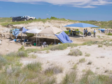
Geologists all around the world are part of teams that drill long, tubular holes into the ground called boreholes. These are usually dug by people looking for oil. A handy consequence of this is that geologists get access to the long tube that was pulled out to form the hole, called a core sample.
In total, Dr. Clarey and his team used data collected from over 1,500 geologic columns across North America, Africa, and South America. This allowed them not only to identify megasequences in each core sample but also measure their thickness. With that, they created a three-dimensional map of each one across all three of the continents being studied. By trying to figure out how each megasequence formed during the Flood, Dr. Clarey’s team rewound the tape, as it were, to reconstruct the arrangement of the oceans, lowland areas, and upland areas of the pre-Flood world.

Based on their newfound knowledge on the makeup of megasequences, Dr. Clarey and his team have proposed a theory, the Ecological Zonation-Megasequence model (EZMD). Using this model will allow us to “travel” back in time and experience what the world of Noah’s time may have really been like before the destruction of the Flood!
Ecological Zonation-Megasequence Model
A Big Look at the Pre-Flood World

What Was It Like?
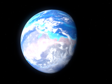
Let’s begin our adventure by jumping in a time-traveling rocket ship. After traveling thousands of years into the past, we now peer back on the earth in its original created state.
The earth’s surface doesn’t look quite the way we’re used to. For one thing, the seven continents of our modern world do not exist. They form a single pre-Flood supercontinent called Pangaea with a narrow, inland seaway running between North America and Africa/Europe. One day, this pre-Atlantic seaway will close up during the early phases of the Flood, scrunching the continent together before the Flood violently rips it apart. But for now, it is still a beauty to behold.
Why Do They Think That?
Current thought holds that our modern continents forged from a single supercontinent, similar to Pangaea. However, debate exists over the exact configuration of that original supercontinent. Some young-earth geologists think the original supercontinent was Rodinia, a smaller but more chaotic supercontinent centered around the South Pole. If this is the case, Rodinia would have broken up early in the Flood, temporarily come together again to form Pangaea, and then separate a final time to form our current continents.
Dr. Clarey suggests that the original continent was more like Pangaea and centered around the Equator. His evidence for this is that Pangaea represents the most natural jigsaw puzzle-like fit for the continents. Can you see how snuggly South America would fit alongside Africa? It also reduces the amount of continental movement during the Flood. His model includes a narrow seaway (about 300 to 500 km) that separates North America from Africa and Europe. He thinks that the closure of this seaway—and the collision of North America with Africa and Europe—caused the Appalachian and Caledonian mountains to rise before Pangaea broke apart.
Shallow Seas
What Was It Like?

Coming in hot from the early earth’s atmosphere, we make a splash into our first stop: the shallow seas of the pre-Flood world. You may be surprised to discover that many regions of the world that will be dry land in the 21st century are underwater. Much of North Africa, the Middle East, the eastern United States, and even the American Southwest act as floors for these shallow seas. Shallow seas also cover what will one day become the western coast of South America and the Amazon basin.
Diving below the waves, we find an assortment of thriving plant and animal communities unlike any on the earth in our time. In the deep waters far from shore lurk jawless fish and spiny sharks (acanthodii). There are also huge, bone-crushing placoderms, such as Dunkleosteus, a monster fish that could have eaten Jaws for breakfast! It might be safer to stick to the nearshore coastal waters. Here, trilobites scuttle across the ancient seafloors, where clam-like brachiopods, sponges, starfish, sea urchins, and worms are eking out a living. Keep clear of the jellyfish and their stinging tentacles, and you could catch a glimpse of the Pikaia, an alien, fish-looking creature making its home here.
Why Do They Think That?

Why do Dr. Clarey and team think so much water covered the pre-Flood world? There are three primary reasons for this. Firstly, we would expect the earliest Flood-bourne sediments to fill in the low-lying regions (like shallow seas) of the pre-Flood world. Second is that the lowermost megasequences, the Sauk, Tippecanoe, and Kaskaskia, cover almost identical parts of the globe. Third, these megasequences are much thinner than the ones formed later. These three things, Dr. Clarey says, suggest that these areas were the first to be affected by the Flood before the waters rose high enough to overwhelm the land. Inland seas already covered these places before the Flood. When the Flood began, the turbulence of the rising floodwaters engulfed them.
The sheer number of marine life in these waters is no coincidence. After all, over 99% of animal fossils found in the Sauk, Tippecanoe, and Kaskaskian are marine creatures. Since the Sauk and Tippecanoe layers were laid down first, the fossils in them are of organisms that were not transported far from where they were originally living. However, the research team thinks that the Kaskaskian sequence was a mixture of sediments and animals swept in from deeper water farther from shore that was then buried on top of the previous megasequences’ contents.
Check out the following resources to learn more about the Shallow Seas:
The Cambrian Explosion
The Origin of Vertebrates
The Mystery of Jawed Vertebrates
Coastal Lowlands
What Was It Like?

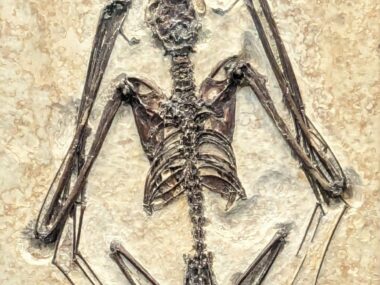
Emerging from the shallow seas we find pre-Flood coastal lowlands filled with a diverse array of ecosystems. Though the large plants dominating this region may look like trees, they are really giant relatives of horsetails. Some tower more than 100 feet into the air! You recognize Lepidodendron and Sigillaria from fossils you’ve seen at the museum in the 21st century. Sometime later, we spot a fishapod or two floating lazily among the water plants. Traveling upstream takes us deeper into the swamp. To our right, we spot a griffinfly (giant dragonfly-lookalike) landing on the branch of a lycopod, the sunlight glistening off its wings. Instead of fishapods, there are giant amphibians patrolling the waterways.
But we have still not left the coastal lowlands, even as our journey takes us further upstream. The swampy forest gradually gives way to near-coastal tropical rainforests of conifers and other trees. It is drier here, allowing larger land animals to flourish. We spot non-mammalian synapsids, like the sail-backed Dimetrodon, resting peacefully in the shadows of ginkgo trees, cycads, and seed ferns.
Why Do They Think That?

The Sauk, Tippecanoe, and Kaskaskia megasequences contain mostly marine fossils and cover about the same approximate areas on the continents. However, Dr. Clarey points out that the Absaroka is much thicker and more expansive. In addition to the marine fossils in these layers, we also start to see land plants and animals. These, he thinks, were some of the first land organisms buried in the Flood. Dr. Clarey argues these organisms inhabited broad, coastal lowlands, as evidenced by their presence in the central United States and East Africa.
The switch from water-dependent plants, like Lepidodendron, to those that are less water-dependent, like ginkgoes, reflects the floodwaters encroaching even further onto the land. This suggests that there was a gradient of ecological communities in the pre-Flood era. Near the coast existed swamp-like communities, and further inland drier rainforests. While non-flowering plants are numerous here, flowering plants, called angiosperms, are virtually absent.
Check out the following resources to learn more about the Coastal Lowlands:
Fins to Feet Transition
Missing Early Evolution of Land Vertebrates
Enigma of the Carboniferous Explosion
The Global Flood Solves Permian Perplexities
Dinosaur Peninsula
What Was It Like?
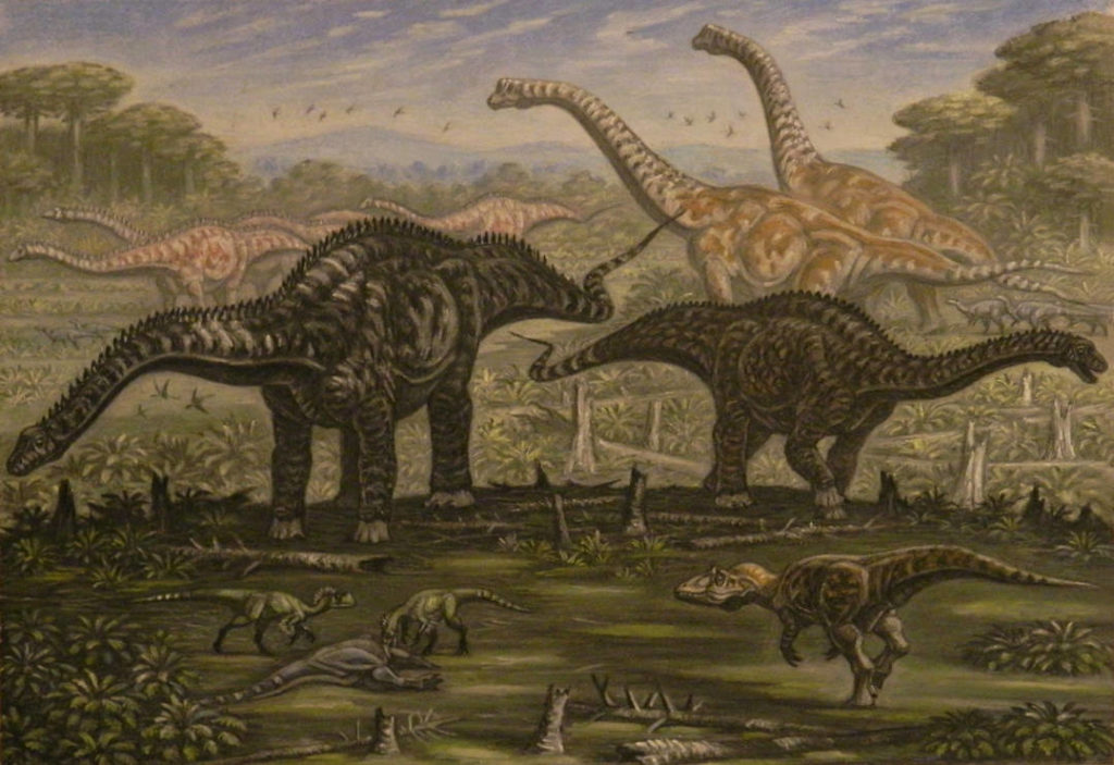
We’ve reached the end of the river and must continue the rest of our journey on foot. The region we travel now is a long strip of low-lying land, from what will become Minnesota to New Mexico. We call this the Dinosaur Peninsula. Dinosaurs live all over the world, but this is the land they inhabit in North America.
Dinosaurs of all shapes and sizes rule a series of tropical and semitropical ecosystems along this peninsula. Some of the first dinosaurs we see are small theropods (meat-eating dinosaurs), perhaps Coelophysis. These scatter as large non-mammalian dicynodonts plod past. Traveling further inland, we come across a pair of long-necked Diplodocus stripping the conifer branches of their needles. An Allosaurus lurks in the shadows, knowing it is far too small to take on something as big as a Diplodocus. We move on too, not wanting to become its next meal. At long last, we come across a Tyrannosaurus, curiously eying a herd of Triceratops browsing on the forest’s lush undergrowth. Flying reptiles, called pterosaurs, swoop overhead.
Notably absent from these environments are any of the mammals we might be familiar with. What mammals we have seen so far are small, rodent-like creatures. The elevation is increasing the further we travel from the sea. Maybe we will find familiar mammals there?
Why Do They Think That?
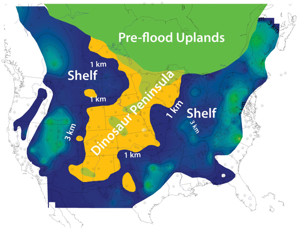
Dinosaurs do not show up until the upper Absoroka and throughout the Zuni megasequence. They are completely absent from the previous three megasequences. Why do they appear so late in the fossil record? As you will recall, the previous three megasequences are relatively thin and had about the same amount of geographical coverage. Dr. Clarey and his team think that this is because the upper Absoroka and Zuni formed in areas already underwater when the Flood began, before the floodwaters started rising over the dry land. Both these megasequences are much thicker and cover a wider, broader area. This, Dr. Clarey suggests, is because the dry land was starting to become flooded.
Dr. Clarey argues that the earlier Flood deposits did not bury the dinosaurs because the Flood had not yet reached the regions they inhabited. He hypothesizes that most North American dinosaurs lived on a stretch of land called the Dinosaur Peninsula. In addition, he does not believe that all of the dinosaurs were overwhelmed at once. Rather, this peninsula was successively flooded in stages. Each stage of Absaroka and Zuni flooding swept away plants and animals, burying them to the west of their habitat . The flooding started at the southern end of the peninsula, overwhelming dinosaurs and other organisms buried in the upper Absaroka. It wasn’t until much later that the floodwaters caught up to the rest of the dinosaurs on the higher elevated northern part of the peninsula.
Check out the following resources to learn more about the Dinosaur Peninsula:
Tumultuous Triassic Tussle
Jostle in the Jurassic
Capping a Cretaceous Conundrum
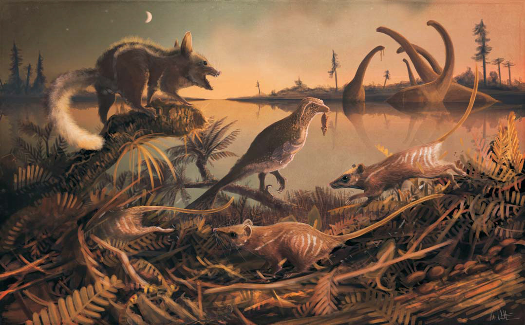
Pre-Flood Uplands
What Was It Like?
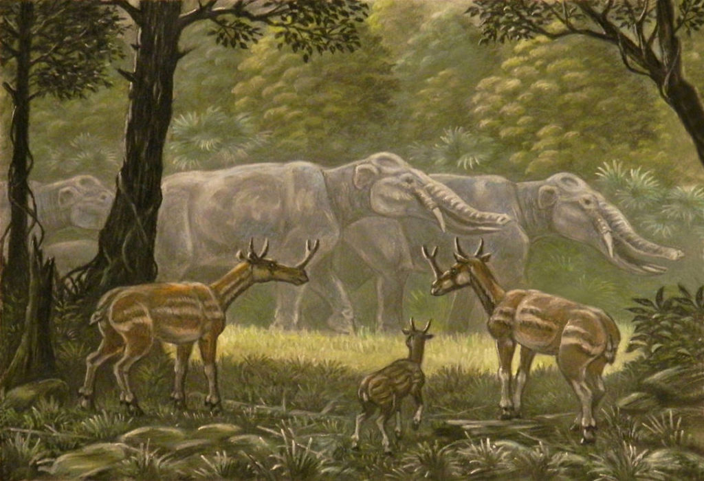
Our final stop on our safari through the pre-Flood world takes us north to what will become Canada. We observe that we are increasing our elevation as we continue traveling. The climate and forest plant life are noticeably more temperate here. We have left the hot, tropical climate of the dinosaurs in the lowlands. These are the pre-Flood uplands.
We are surprised by just how many types of animals we recognize from the 21st century. We spot horses and rhinoceros grazing on the lush grasses in the plains. In the woods, we spot a herd of elephants ambling through the trees toward the river for a drink. Startled by our presence, we hear the piercing cry of a turaco in the branches above our heads. You catch the whiff of smoke, at first alarmed at the thought of a forest fire. But you quickly realize that it is the smell of food cooking over an open fire. This is a sure sign that humans may be nearby. That’s an exploration for another day.
Why Do They Think That?

No matter their thickness or coverage, all megasequences become thinner and eventually pinch out all together the closer they get to crystalline shield areas, called shields. Dr. Clarey thinks that the reason they become thinner is because they were laid down along the flanks of what were extensive uplands in the pre-Flood era. There are many such shields around the world, in places like Brazil, Canada (i.e. the Canadian Shield), Greenland, and Central and Western Africa.
One of the peculiar observations that distinguishes the Tejas from the other megasequences is this: according to the Column Project, it was receding floodwaters that laid down the sediment and fossilized lifeforms in the Tejas. These animals and plants are thought to have lived in the pre-Flood uplands (in North America, this would equate to what is now the Canadian Shield). The environment they lived in was more temperate, as it was of higher elevation than the coastal or lowland habitats inhabited by fishapods and dinosaurs, respectively. These regions were the home of many types of familiar organisms, like large mammals, birds, and flowering plants. Instead of being buried in the uplands where they lived, these regions were eroded and all sediment, animals, and plants on top of them were transported great distances before being laid down on top of earlier megasequences.
It is possible that these uplands were where pre-Flood humans were located. Could the Garden of Eden be found? It is unlikely, as these regions were heavily eroded right down to the bedrock God formed during Creation Week. Nevertheless, the tentative discovery of pre-Flood uplands concludes our exploration of the pre-Flood world.
Check out the following resources to learn more about the Pre-Flood Uplands:
The Surly Cenozoic Final Finale
Conclusion
The work by Dr. Clarey and his team is a huge advancement in not only Flood geology research but also geologic correlation research as a whole. It provides a data-driven explanation for the order of the fossil record and, for the first time, tentatively proposes the geography of much of the pre-Flood world. With investigation into other continents well underway, Dr. Clarey hopes to provide clarity to the world that then was.


Good idea on the Safari. yet I disagree with too much. I think we must imagine a superior place. lets say beautiful black dirt thousands of feet thick with no stones. Impacts are here and there from space rocks. Yes a shallow non salt sea with glorious life around a single continent probably. I don’t agree with these megasequences in rock. Anythings possible but the essence of the flood year was great power from moving water depositing sediment and stamping everything down to turn all to stone.
Finally the dinosaurs I say are a myth. they are simply the same creatures we now have in different spectrums within kinds. Any mammal like creatures ever found in fossils were post flood. Never is there a mingling because they never did.Where are the flood mammal fossils?
Anyways this is still the right direction.
have we found the body of an antediluvian man? Thank you
No. GOD said He was going to wipe man off the face of Earth.
Human bodies woudl not be able to remain intact through the rampaging debris laden flood flows.
This article is ridiculous and written by someone who understands neither The Bible or Newtonian Physics!
During The Flood there would be massive flows of topsoil and all its creatures and vegetataion mixed up with flows of subsoil from other locations mixed up with other topsoils and sub soils and sub-subsoils and sub-sub-subsoils and finally large and small peieces of shattered crust aka bedrock. Then during the draindown much of this sediment would again be flowing and mixing and resettling.
In the post-flood years volcanoes would start erupting and building what today are massive cones.
Then in the Upheavals of the Days of Peleg the whole lot would again be lifted, dropped, stirred and flowed and tilted west almost 90 degrees to something like we see today.