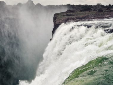
Which layers in the geologic record represent Noah’s Flood? This has proven to be a very controversial topic in young-earth creationism. Scholars have proposed several competing models. Each one presents evidence for the impact the raging floodwaters had on the earth. But there remains one often overlooked detail among creationists regarding the Flood. If our planet once experienced a global Flood, surely it also experienced global drying as well. And this worldwide drying phase should have left telltale clues behind. Fortunately, young-earth researcher Harry Dickens has tackled this angle in a recent research paper published in the Origin Research Journal. In it, he provides evidence that drying and increasingly arid conditions occurred worldwide at a particular time in earth history.
The following article is a summary of “A Proposed Model For The Drying And Related Stages Of Noah’s Flood,” by Harry Dickens, and of the surrounding discussion and research pertaining to it. The views expressed do not necessarily reflect those of New Creation.
A New Way to Find the End of the Flood?
Biblically speaking, it is very easy to tell when the Flood ended. Genesis 8:18 records when Noah, his family, and the animals stepped off the Ark and into a post-apocalyptic world. Every human and air-breathing land animal had perished (Genesis 7:23). The plants had all washed away (Psalm 29:3-10). The dry land surface itself was destroyed (Genesis 6:13). Geologic evidence attests to this. Mountains composed of granite and schist flattened as the continents wore down for miles. And thick packages of marine sediments settled across the submerged continents.
But determining the end of the Flood in the geologic record is a great deal more difficult.1 The Flood had a sudden and catastrophic beginning. We should therefore expect an abrupt change in the character of strata: the pre-Flood/Flood boundary. However, the Flood did not end suddenly or catastrophically. Many months passed before the floodwaters receded. Today, we continue to experience aftershocks from big earthquakes hours, days, or weeks afterward. In much the same way, planet Earth took considerable time to re-establish equilibrium after the biggest catastrophe in its history. The Flood’s aftereffects would have taken centuries or millennia to wear off. This means that a hard and fast boundary between Flood and post-Flood strata will not necessarily be easy to establish. We may not be able to find the exact stratum upon which Noah took his first steps after the Flood.
However, we can search the geologic record for clues we might expect from the Flood’s last stages and immediate aftermath. The Flood swept away all full-grown plants. We should then expect to find evidence of a period before significant plant growth recolonized the post-Flood earth.
Trending Plants
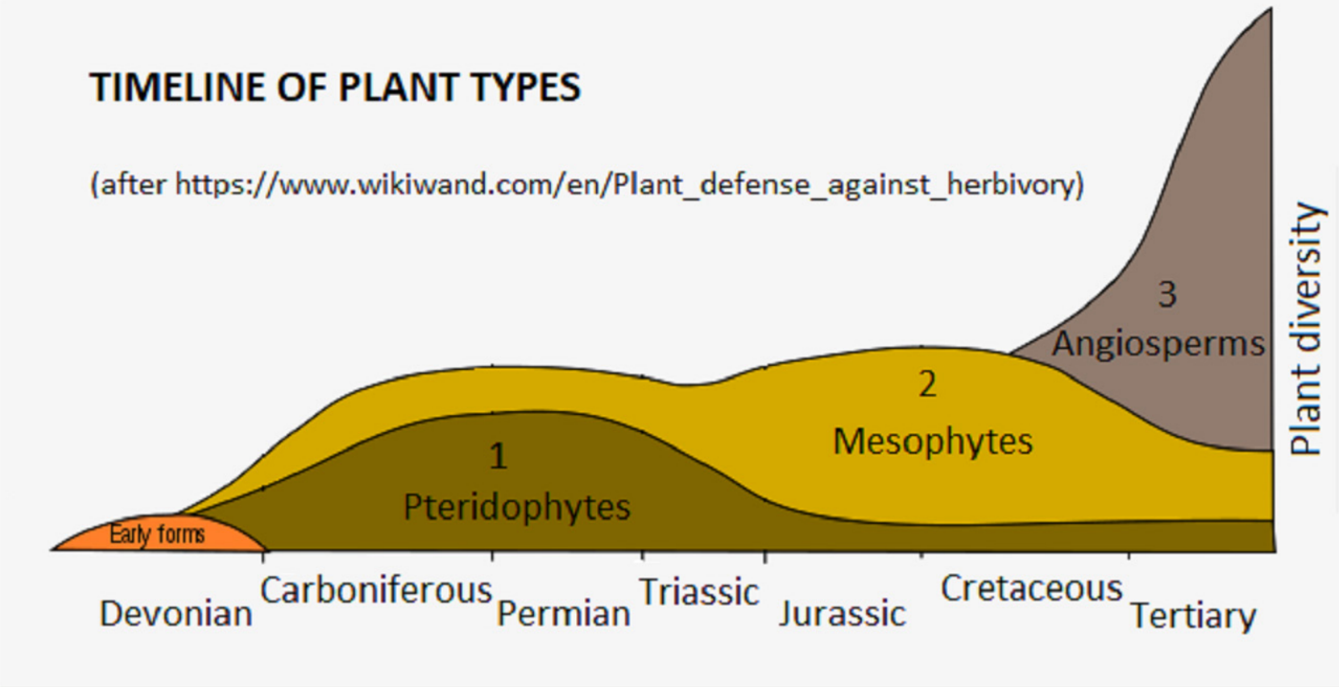
Fossils of major types of plants are found in a particular and predictable order in the geologic record. This pattern reflects which plants were most common and widespread on earth at specific points in time.
But this is not the only way plant remains can help us identify the physical end of the Flood. The major types of plants throughout the geologic record can be classified in terms of their reliance on water. Logically, then, we should see evidence of both the global Flood and the global drying within these plant types. Let’s take a look at the most prominent plants in the different geologic layers, and how much they relied on water.
Pteridophytes

Climate Preference: Very Wet
Clubmosses, ferns, and horsetails are different types of pteridophytes. The tissues of these plants—called vascular plants—specialize in conducting water. This enables them to live in low-oxygen swamp conditions. They do not produce seeds or flowers, but instead reproduce by dispersing spores. Pteridophytes are the dominant plant type making up coal deposits of Carboniferous and Permian layers. These are the largest coal deposits found anywhere in the geologic record.
Mesophytes
Climate Preference: Mostly Dry
Mesophytic plants2 are non-flowering, seed-producing plants. These include cycads, conifers, and many others. While exceptions exist, most mesophytes are better suited to drier conditions than pteridophytes. Some mesophytes first show up in Carboniferous and Permian strata. They dominate the plant fossil record in the Triassic. Later, in the mid- to upper-Cretaceous, they are in turn dominated by angiosperms (flowering plants).
Angiosperms

Climate Preference: Ambivalent
Angiosperms—called “flowering plants” for a good reason—produce fruit. They are the dominant form of plant life from the mid- to upper-Cretaceous right through to present day. Angiosperms reproduce through insect-assisted pollination, where insects help by transferring their pollen from flower to flower. These plants thrive in a variety of habitats —be they wet or dry, cold or hot. Angiosperms are responsible for supplying Paleogene coal deposits. These are the second largest coal deposits in the geologic record, outranked only by those of the Carboniferous and Permian.
Coal 101

Coal is composed mostly of organic matter, specifically land plants. This is very unlike most sedimentary rocks. Coal production occurs when plant matter is buried, compacted, and experiences intense heat and pressure. We find coal on every continent (including Antarctica) and it appears abundantly throughout all systems of the geologic record from the Carboniferous on up. This makes it a window that can give us a glimpse into plant biodiversity throughout the history of earth.
According to conventional wisdom, plants take millions of years to transform into coal. In reality, while time is a factor, the transformation of plant matter into coal is more reliant on temperature.3 One prominent example of this is the Moscow brown coals. Despite their assigned age of more than 300 million years old, they have not reached the more advanced stage that black coals of the same estimated age in Pennsylvania and England have. Why? The deepest that Moscow brown coals were ever buried was only 656 feet below the surface. This kept them relatively cool. On the other hand, the black coals were buried deeper and therefore were exposed to much more heat.
We Don’t Talk About Coal Gap, No, No, No!4
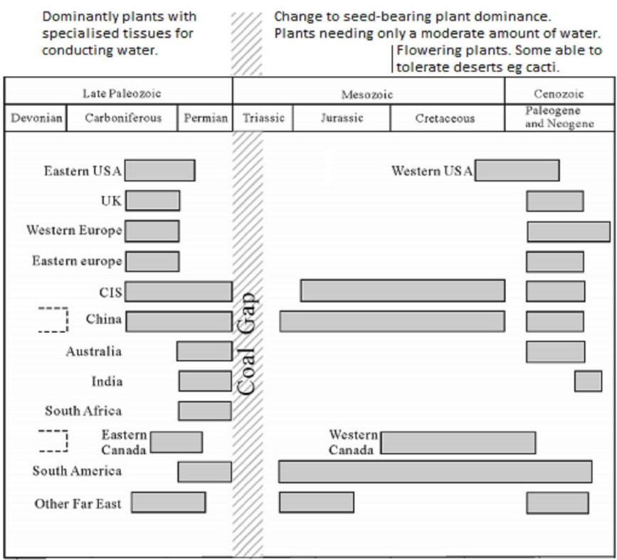
As mentioned above, coal is plentiful throughout the geologic record from the Carboniferous until modern times. But there is one major exception: the Coal Gap. While coal deposits made from pteridophytes (and some mesophytes) are plentiful in Permian strata, they are non-existent in the lower Triassic. Coal deposits do not regain their former plenteous glory until the upper Triassic. These deposits, however, consist primarily of mesophyte plant matter, many of which could thrive in hot, arid climates.
There is no consensus among old-earth geologists as to why the Coal Gap exists. But it is scarcely (if ever) discussed among young-earth geologists either. What is known about the Gap is that it coincides with a drop in biodiversity across the board. Some 70% of Permian land species6 and 81% of Permian marine species7 vanish from the fossil record in the Triassic. Called the “Great Dying,” this is the largest disappearance of species anywhere in the fossil record.
Could the lower Triassic Coal Gap correspond to a time of drying around the whole planet?
Evidence for Drying in the Triassic
If the Triassic really was a time of worldwide drying out, there should be a record for it in the rocks deposited around that time. Indeed, Dickens provides several lines of evidence for this within Triassic strata:
Calcrete

Calcrete is a very common occurrence in Triassic strata. It is a calcium-rich layer of soil or sediment that acts as a natural concrete. It cements together particles of clay, gravel, sand, and/or silt. Today, it forms in arid or semi-arid regions, like the Australian outback and the High Plains of the western United States.
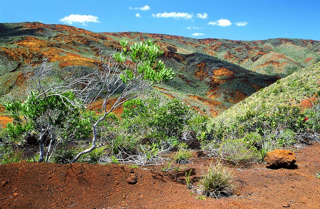
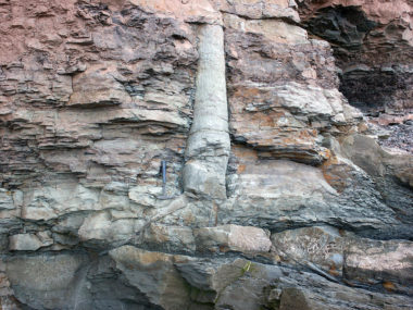
Red Beds
, Goosenecks Point along Sulphur Creek, Capitol Reef National Park, southern Utah 1, CC BY 2.0, https://commons.wikimedia.org/w/index.php?curid=83062186")
Red-colored layers of sedimentary rock (such as sandstone, shale, or siltstone) are called red beds. Their vibrant color comes from oxidation experienced in arid or semi-arid conditions with little rainfall. Red beds are particularly common in the Permian and Triassic strata of North America and Devonian Old Red Sandstone strata of Europe.
Lake Deposits

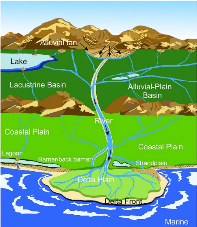
True lake deposits should be absent from strata formed during the Flood. How do geologists recognize them in the geologic record? The presence of fine-grained sedimentary rocks (like siltstone, claystone, and limestone) arranged into thin, well-sorted layers is one helpful clue. Lakes often leave these types of deposits behind when they dry up. The types of fossils these deposits contain are another clue. Fossils of freshwater fish, algae, shellfish, and other organisms are a good sign that we are looking at a lake deposit. Young-earth geologists have used these and other criteria to identify ancient lakes elsewhere in the geologic record. For example, research by Dr. John Whitmore strongly indicates that the Green River Formation represents a series of intermountain lake deposits.
River Styles

Sedimentary deposits associated with the Permian-Triassic transition are characterized by a switch from meandering rivers to high-energy braided streams, often associated with alluvial fans.8 A braided stream is a network of multiple shallow river channels that diverge and rejoin around small, often temporary, islands (sort of like braided hair). Whereas alluvial fans are accumulations of sediments that fan out from a concentrated source of those sediments, like narrow canyons that emerge from steep slopes or tall cliffs. These observations are consistent with a trend toward more arid conditions and geological processes such as mass wasting.
Evaporites

Evaporites are a type of mineral deposit. They form when a mineral-rich body of water, such as a salt lake or an inland sea, evaporates. Left behind are thick deposits of minerals like aragonite, anhydrite, calcite, gypsum, and halite (salt). The salt flats of Utah are an excellent example of this phenomenon. Evaporite deposits become more widely distributed as the Permian strata transitions into Triassic strata.
Sea Level Drop

Geologists widely recognize that the greatest drop in sea level in earth history coincides with the Coal Gap. Evidence of this is the reduction of marine deposits on the continents as more dry land became exposed. The common theory suggests this resulted in extreme and arid climates in inland regions. This benefited plants that could resist heat and aridity, like many mesophytes.
Coal Before and After the Gap
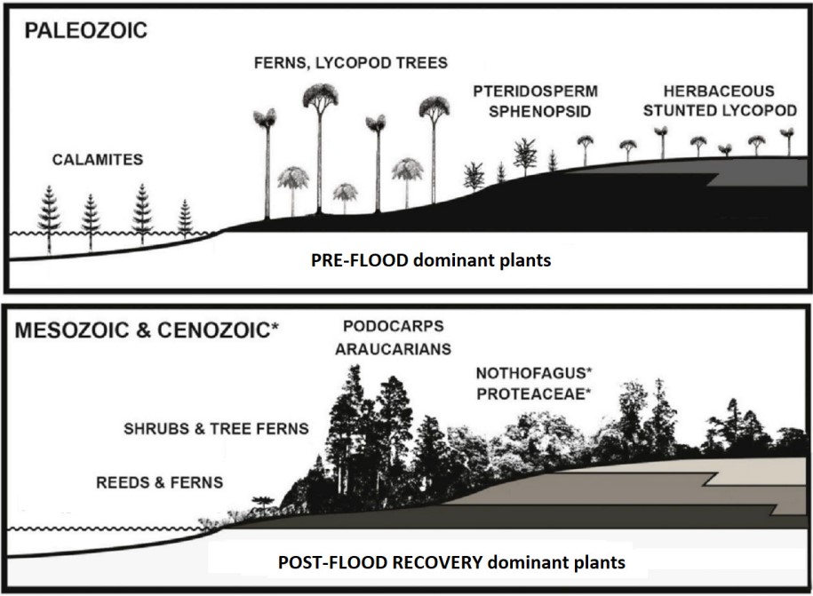
If evidence for worldwide drying can be found in Triassic strata, then coal deposits below these layers are most likely associated with plant life from before the Flood. Dickens thinks pre-Flood land plants are the source of Carboniferous and Permian coal deposits, plants stripped off the land surface by the surging floodwaters. They floated during the high sea levels of the Flood, only making landfall and burying within sediments as the floodwaters receded.
A common feature of Carboniferous-Permian coal-bearing strata are repeating sequences called cyclothems. They are indicative of repeated rising and lowering of sea level or the submergence and emergence of dry land. Either one is consistent with what Scripture records concerning the latter half of the Flood. At this time, the floodwaters moved to and fro as they receded (Genesis 8:3-5). Dickens postulates that the Coal Gap in the Triassic reflects a brief period of time after the Flood before plants recolonized the earth. Without plentiful plant life on the land, there was no source to produce coal.
As described above, mesophytes primarily compose the coal deposits between the Coal Gap and the mid-Cretaceous. In contrast, angiosperms dominate the coal deposits from the mid-Cretaceous layer until the present. Dickens argues that all coal deposits above the Coal Gap formed well after the global Flood. What post-Flood processes buried so many plants and converted them into coal?
Division of the Earth
“To Eber were born two sons: the name of the one was Peleg, for in his days the earth was divided, and his brother’s name was Joktan.”
Genesis 10:25 & 1 Chronicles 1:19
What is this “division” referring to? Most young-earth creationists think that this is a nod to the division of nations from Babel described in Genesis 11. However, the late Hebrew scholar Bernard Northrup argued instead that palag (the Hebrew word translated as “divided”) refers to a division by water.10,11 The root word for palag in Arab and Ethiopic, closely related Semitic languages to Hebrew, means “river.” In classical Greek, there are 18 nouns that use the same root for palag, all of which relate to oceans. In fact, we still use two of these words today: pelagic and archipelagos. Northrup also points to palag’s usage in Job 38:25, where God asks, “Who has divided a channel for the overflowing of water…?”

Furthermore, Northrup argued that this division of the earth recorded in Genesis 10:25 may be referring to the opening of the Atlantic Ocean as the ancient supercontinent of Pangaea broke apart. Assuming the Masoretic timeline, Peleg was born about a century after the Flood and died at the age of 239. Dickens notes that this correlates well with the Flood ending by the Triassic, since the beginning of Pangaea’s breakup began in the early Jurassic.
Coal After the Flood
The mode by which Dickens postulates coal formed after the Flood relates to the geologic processes involved in the breaking up of Pangaea, called tectonism. This produced new seaways and coastlines, and generated mountain building. Sea levels rose much higher in the mid-Cretaceous than they today. However, they were restricted to shallow, inland seas. To a smaller extent, we have several shallow, inland seas today. The Mediterranean Sea and Caspian Sea are two prominent examples.
Recall that plants better suited to drier conditions dominated through most of the Mesozoic. Overtime, angiosperms of the Cenozoic largely replaced these plants. Heavy rain and the rise of mountains after the Flood caused a lots erosion to occur. In the process, plants were swept away, transported, and accumulated into low-lying areas. Here, sediment buried them in basins adjacent to ancient inland seas and lakes. Eventually, they transformed into thick deposits of coal.
Conclusion
In science, it is often helpful to engage with multiple working hypotheses when there remain many unknowns, as is the case with many aspects of young-earth geology. Though perhaps not the most conventional Flood model, Dickens provides a compelling case that the Triassic was a time of worldwide drying out after a worldwide Flood. It explains many lines of evidence that other young-earth models have not yet tackled, such as the Coal Gap and evidence for increasingly arid conditions in the Triassic. It also aims to document the gradual drying out and revegetation of the planet.
Dickens hopes that the data presented in his paper encourages further discussion as creationists work together to resolve the Flood/post-Flood boundary debate.
Footnotes
- Whitmore, J. and Garner, P. 2008. “Using suites of criteria to recognize pre-Flood, Flood, and post-Flood strata in the rock record with application to Wyoming (USA).” In: Snelling, A.A. (Ed.), Proceedings of the Sixth International Conference on Creationism, Creation Science Fellowship, Pittsburgh, PA, and Institute for Creation Research, Dallas, TX, pp. 425–448. ↩︎
- Not to be confused with “mesophytes,” a different group of plants by the same name. ↩︎
- Bruce, R. 2021. “Millions of years are not necessary for petroleum formation.” Journal of the Bible Creation Trust, 3, 7-11. ↩︎
- This is not a “We Don’t Talk About Bruno” reference. Move along. ↩︎
- Shao, L., Wang, X., Wang, D. et al. (2020). Sequence stratigraphy, paleogeography, and coal accumulation regularity of major coal-accumulating periods in China. International Journal of Coal Science and Technology 7, 240–262 ↩︎
- Sahney, S. Benton, M.J. 2008. “Recovery from the most profound mass extinction of all time.” Proceedings of the Royal Society B. 275 (1636): 759–765. ↩︎
- Stanley, Steven M. 2016. “Estimates of the magnitudes of major marine mass extinctions in earth history.” Proceedings of the National Academy of Sciences. 113 (42): E6325–E6334. ↩︎
- It should be noted that Dickens does not have modern equivalents for rivers in mind here. The late-Flood and post-Flood time periods were very dynamic. In addition, sedimentary deposits forming during these times were formed very quickly and alongside a rapidly changing environment. ↩︎
- Dai, S. et al. 2020. “Recognition of peat depositional environments in coal: A review.” International Journal of Coal Geology, 219(103383), 1-67. ↩︎
- Northrup, B.E. 1979. “Continental Drift And The Fossil Record.” Central Bible Quarterly, 22(4): 2-27. ↩︎
- Northrup, B.E. 2004. “The Grand Canyon and Biblical Catastrophes.” Chafer Theological Seminary Journal. 10:2: 74-101. ↩︎


Appreciate this article: even though I disagree with Dickens, I appreciate him bringing up new problems that Steve Austin, Andrew Snelling, and other geologists need to answer.
Important and fine article. i say the flood line is the old k-t line. after that the fauna/flora is like the present day. the flood changed the flora/fauna ratios and types. after the flood YES the seas were less deep. Whether less water or lower continents displacing the water. then , perhaps, the continents rose and the water cut off more of the land. this causing volcanic action like crazy and bringing on the ice age. all to allow the prophecy that Japheth would inherit most places and not the others. or rather the food suppl for people vanished in northern areas.