Young-earth geologists have produced several models of earth history in order to better understand how geological facts correlate with Scripture. At New Creation, we like to explore how well these models explain the data and what potential avenues of future research they might provide. One persistent problem young-earth history models have so far is being able to demonstrate a clear chronological sequence that aligns both the scriptural narrative and specific evidence found in the geologic record. Geologist Harry Dickens has presented a new young-earth history model, called “Receding Then Spreading” (RTS). This model presents a novel approach to address this problem. It intertwines regional case studies with biblical stages in meticulous order.
The following article is a summary of “Receding Noahic Flood Waters Led to Seafloor Spreading: A Proposed Geological Model,” by Harry Dickens, and of the surrounding discussion and research pertaining to it. The views expressed do not necessarily reflect those of New Creation.
Problems with Current Young-Earth History Models
Anyone familiar with the literature of young-earth creationists will know about several earth history models they have proposed. Each one differs in their views on how the geologic record formed during the pre-Flood, Flood, and post-Flood eras. They also vary on the exact mechanisms for the Flood.
Among these, Catastrophic Plate Tectonics (CPT) is widely accepted by young-earth geologists. This model proposes that the breakup of a single pre-Flood supercontinent was the mechanism God used to bring about the Flood. Hydroplate Theory (HPT), less represented in young-earth scientific literature, is another proposed model. It posits that massive sub-crustal water chambers caused crustal fractures, flooded the planet, and formed today’s continents. But Dickens argues both CPT and HPT have a central problem: neither of these models correlate all the major stages of the Flood recorded in Scripture directly with specific regional geology. A key example is that the geological evidence for months of drying recorded in Genesis 8 is apparently missing in these models. The two common views on the Flood’s end (KPg and Cenozoic) also lack this scriptural factor, as well as associated geological evidence for drying.
“Receding Then Spreading” (RTS) is a different view than previous Noahic Flood models. Dickens took descriptions of geologic formations in key regions. Then, he correlated them with the historical stages evident as recorded in the book of Genesis. This enabled him to develop an innovative young earth history model. This model includes the receding waters and the drying phases of the Flood Year. The name, “Receding Then Spreading,” refers to the idea that the receding waters of Noah’s Flood actually triggered the separation of continents into their current arrangement. This is a distinction from both CPT and HPT, which have the separation of continents occurring during the Flood.
Groundtruthing with Flood Geology 101
Dickens introduces us to a method he calls “ground truthing”. He uses this method to bridge the existing gap between the scriptural account of the Flood and the geological record. In an earth history context, this term is literally derived from the idea of establishing truth on the ground. The goal is to ensure that as much of an earth history model as possible is “grounded in truth.” In other words, the model needs to align with the actual geological features present in the earth’s rock record. This type of approach is especially important when dealing with complex historical events, such as Noah’s Flood.
Many people perceive Noah’s Flood as a “single event” with minimal post-Flood geologic activity. However, both the Flood narrative in Genesis and the geological evidence suggest otherwise. There were distinct phases during the Flood, each leaving behind telltale evidence. We can use this evidence to distinguish each phase from the phases that preceded and succeeded it. According to Dickens’ model, geologic activity persisted beyond the Flood itself. Geologic activity continued to transform the earth for centuries, featuring shifting continents, mountain formation, fluctuating sea levels, and diverse climates.
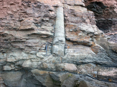
Scientists envision the worldwide trends and patterns expressed in the various rock types and fossils making up the earth’s crust as the geologic column. Dickens’ RTS model recognizes the Flood as being directly responsible for the lower portion of the geologic column, laying down thick packages of marine sediments and fossils. However, he proposes the Flood was also responsible for the upper portion of the geologic column as the earth recovered from a worldwide cataclysm.
The RTS model also aims to explain a host of other geological phenomena often overlooked in young-earth history models. These include extensive erosion surfaces between rock layers (called unconformities), global sea level fluctuations, evidence of widespread drying and inland seas, and even a brief Ice Age.
With expertise in geology and a deep understanding of God’s Word, Dickens endeavors to “ground truth” the biblical events of the Flood and their aftermath with the geologic record beneath his feet.
Phase 1: Fountains Burst
“In the six hundredth year of Noah’s life, in the second month, on the seventeenth day of the month, on that day all the fountains of the great deep burst forth, and the windows of the heavens were opened.”
– Genesis 7:11, ESV

While there is general agreement that the opening of the “windows of heaven” refers to torrential downpours, there continues to be much discussion between young-earth geologists and Bible scholars as to the nature of these “fountains of the great deep.” Dickens understands this event to correspond with the breakup of the original, pre-Flood supercontinent. When the pre-Flood supercontinent tore apart, the waters “burst forth” from the resulting fractures. Below, we will describe in more detail one of the fracture zones from which Dickens proposes the water came from. It should be noted that this is different from CPT, which posits no extra water was added to the oceans. Rather, CPT claims the ocean’s holding volume shallowed by the production of new oceanic crust, which forced the ocean water out of the ocean and onto dry land. RTS, on the other hand, argues that water poured out from these fragmentation sites.
Groundtruth:
Darling Fault Zone
. Structure and tectonics of the Leeuwin Complex and Darling Fault Zone, southern Pinjarra Orogen, Western Australia—a field guide.")
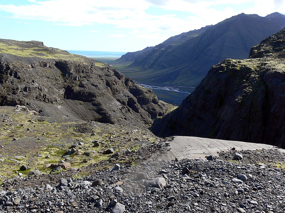
The Darling Fault Zone is a major fault system that stretches over 620 miles across the western margin of the continent of Australia. This fault zone is the result of tectonic movements, where sections of the earth’s crust have shifted in relation to each other.
Though Australia is far-removed from Greater India today, the Darling Fault Zone is a region where the continental crust of these two landmasses fragmented apart. Studies of minerals that formed at the time of the fragmentation suggest hydrothermal fluid alteration. As such, Dickens reasons that the Darling Fault Zone may provide evidence for one region that housed “fountains of the great deep” spoken of in Genesis.
Phase II: Marine Transgression
“For in seven days I will send rain on the earth forty days and forty nights, and every living thing that I have made I will blot out from the face of the ground.”
– Genesis 7:4, ESV
“For as in those days before the flood they were eating and drinking, marrying and giving in marriage, until the day when Noah entered the Ark, and they were unaware until the flood came and swept them all away, so will be the coming of the Son of Man.”
– Matthew 24:38-39, ESV
This phase of the Flood is recorded throughout the Bible. The text vividly described how great surges of water flowed over what was once dry land, sweeping away everything in its path. Another possible reference to the Flood was recorded by one of the psalmists, which speaks of pre-Flood vegetation being swept from off the land (Psalm 29:5-10). This occurred until the planet’s surface was submerged beneath a global ocean. Logs ripped off the land, being more buoyant, would have floated. This helps explain the lack of early Paleozoic coal deposits.
Dickens suggests that this reflects the destruction of the pre-Flood world and the subsequent emplacement of thick packages of marine sediments over what was once dry land. 40 days and nights of rain sent slurries of water across the continents, wiping them clean of sediment, humans, animals, and plant life. This may explain the lack of many pre-Flood land vertebrates from the Paleozoic fossil record. Their remains were swept away and abraded, leaving no macrofossils behind. Large pre-Flood land plants floated and were not fossilized in early Paleozoic strata. According to this model, the only fossils from early in the Flood Year are those of shallow water marine organisms that were swept onto the submerged continents and buried as floodwaters rose.
Groundtruth:
Sauk Sequence, Worldwide
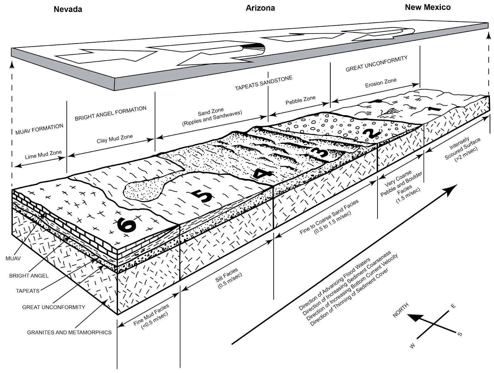
All over the world, there exists a sequence of rock layers called the Sauk Sequence. The base of this sequence is composed of large cobble and boulder layers at the very bottom, transitioning to layers of sand, layers of marine shales (a type of mudstone), and finally the especially fine-grained sediments such as limestone. The Sauk Sequnece overlies an erosion surface into granite and schist called the Great Unconformity. This pattern reflects the widespread erosion of rock, followed by a worldwide rise in sea level, as indicated in Scripture.
Phase III: Marine Regression
“The fountains of the deep and the windows of the heavens were closed, the rain from the heavens was restrained, and the waters receded from the earth continually. At the end of 150 days the waters had abated, and in the seventh month, on the seventeenth day of the month, the ark came to rest on the mountains of Ararat. And the waters continued to abate until the tenth month; in the tenth month, on the first day of the month, the tops of the mountains were seen.”
– Genesis 8:2-5, ESV
“The mountains rose, the valleys sank down to the place that you appointed for them.”
– Psalm 104:8, ESV
After the fountains of the deep ceased bursting and the rain stopped, the floodwaters receded. But where did all of this water go? Dickens proposes that seawater flowed down into the top of the Earth’s mantle. The seawater returning to the Earth’s mantle made the rocks more wet and pliable. This created special types of minerals and made it easier for rocks to melt into magma. The water also softens the rocks, making them less resistant to movement and helping the mantle to flow more easily. As we shall discuss in greater detail later, this would activate plate tectonic processes and trigger seafloor spreading after the actual year of Noah’s Flood.
Groundtruth:
Global Recession
 2, CC BY 2.0, https://commons.wikimedia.org/w/index.php?curid=83064051")
As far as unconformities go, the Great Unconformity seems to get all of the attention. But there is another unconformity situated in the mid-Carboniferous portion of the geologic column. (For context, we in the U.S. refer to the mid-Carboniferous as the boundary between the Mississippian and Pennsylvainian layers.) It exists worldwide (North America, North Africa, Europe, the Urals, Turkey, Uzbekistan, China, Australia, and South America). Dickens proposes it formed as waters of Noah’s Flood withdrew from the continents.
Finally, the recession of floodwaters also offers an alternative explanation for so-called “glacial” deposits from the supposed Late Paleozoic “Ice Age.” These deposits are often associated with movements of massive glaciers over the earth’s surface. Dickens suggests that these deposits formed instead from mass flows rather than glacial activity, a viewpoint advocated even in mainstream geological literature.
Dickens infers that extensive Carboniferous and Permian coal deposits represent floating pre-Flood vegetation that flowed with receding waters into low-lying areas and were then covered by sediment. These coal plants were more suited to wetter conditions than plants found in post-Paleozoic coal deposits which were formed in the time of seafloor spreading and continental mountain-building.
Phase IV: Drying Phase
“In the six hundred and first year, in the first month, the first day of the month, the waters were dried from off the earth. And Noah removed the covering of the ark and looked, and behold, the face of the ground was dry.”
– Genesis 8:13, ESV

Dickens draws special attention to an important phase of the Flood often overlooked in young-earth geology models. If the earth experienced global flooding, it must have also experienced global drying. Dickens correlates this critical phase, lasting eight weeks or so, with the emergence of dominant new vegetation growth, which had adapted to drier, post-Flood conditions. Noah may have waited for the growth of this vegetation as it could have provided food for the animals disembarking the Ark.
Groundtruth:
Triassic Redbeds
 capped by Shinarump Conglomerate Member of Chinle Fm. (Upper Triassic), Virgin River Valley near Zion National Park, sw Utah 4, CC BY 2.0, https://commons.wikimedia.org/w/index.php?curid=83062105")
Triassic red beds around the globe exhibit land-derived deposits, evaporites, and other evidence suggesting dry, non-marine environments. Calcrete and minerals like gypsum, anhydrite, and laterite are prominent indicators of aridity; they form under conditions of climate fluctuation and intense weathering. The transition from meandering to high-energy rivers, plus the expansion of alluvial fans at the Permian-Triassic boundary, indicate both an environment becoming more arid and a worldwide drop in sea level.
Coinciding with these drying climate conditions are changes in types of plants we find as fossils. Tough plants that could handle extreme and dry conditions, like conifers, become more common. Notably, there are no coal layers in lower Triassic rocks. Scientists call this absence of coal the Coal Gap. This gap lasts until the middle of the Triassic where thin coal layers start showing up again. Dickens suggests that the Coal Gap represents a drying phase after the floodwaters went down, but before significant plant growth began. He maintains that the scriptural record of the drying floodwaters explains the Coal Gap.
Phase V: Seafloor Spreading
“The mountains rose, the valleys sank down to the place that you appointed for them. You set a boundary that they may not pass, so that they might not again cover the earth.”
– Psalm 104:8-9, ESV
“To Eber were born two sons: the name of the one was Peleg, for in his days the earth was divided, and his brother’s name was Joktan…”
– Genesis 10:25 & 1 Chronicles 1:19, ESV

As the floodwaters flowed off the earth’s surface after the Flood, a critical change occurred in regions where the pre-Flood supercontinent fragmented. The floodwaters receded into the earth’s mantle, making it easier for the rocks to melt and flow. This led to the spreading of the seafloor. Coinciding with seafloor spreading was the breaking up of the early post-Flood supercontinent of Pangaea. Dickens suggests that the mention of a “divided” Earth during the lifetime of Peleg aligns with continental rifting and seafloor spreading occurring at this time.
During this time, we also see a transition in the dominant types of plants and animals. Dinosaurs became extinct within the hundreds of years following the Flood. This allowed mammals (which remained less prolific during the dinosaurs’ reign) to increase in number and become widespread. Flowering plants also became more numerous and widespread, replacing many of the niches once filled by non-flowering plants, such as conifers and ferns.
 - https://web.archive.org/web/20050115222718/climweb.cr.usgs.gov/research/fossils/ammonites.html, Public Domain, https://commons.wikimedia.org/w/index.php?curid=69467")
Groundtruth:
Inland Seas
Seafloor spreading resulted in decreased volume of the ocean basins. This caused the ocean water to overflow into low-lying regions of the continents, creating vast inland seas. The most well-known of these is the Western Interior Seaway that once cut the North American continent in two. We have found evidence for the existence of this seaway within the marine rock layers and fossils in this region of the continent.
Phase VI: Glaciation
“From whose womb did the ice come forth, and who has given birth to the frost of heaven?”
– Job 38:29, ESV.
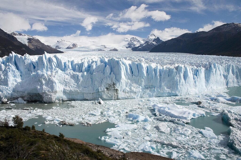
Seafloor spreading and underwater volcanic activity triggered a cascade of events that culminated in the Glaciation phase, otherwise known as the Pleistocene Ice Age. The release of hot volcanic water into the ocean warmed its temperatures significantly. Subsequent intense evaporation from this warmer ocean became a critical factor in the formation of vast ice sheets. Sea levels dropped as a result, allowing for canyons to form in places previously underwater. These ice sheets reduced global temperatures and initiated the Ice Age cycle.
Groundtruth:
Perth Canyon, Western Australia
. First ROV exploration of the Perth Canyon: Canyon setting, faunal observations, and anthropogenic impacts. Frontiers in Marine Science, 6, 173.")
The accumulation of ice on the land caused sea levels to drop worldwide by hundreds of feet. This drop in sea level exposed most continental shelves, leading to extensive erosion and the formation of submarine canyons. These canyons, found across continental shelves worldwide, shaped during the Ice Age, with rivers carving valleys into what is now the continental shelf. This activity sculpted large canyons across continental shelves around the planet. One of them is Perth Canyon, currently more than 18 miles offshore from Perth, Western Australia. As Australia’s largest submarine canyon, it stretches roughly the length of the Grand Canyon and plunges twice as deep, reaching depths of almost two and a half miles below sea level.
Weighing the Evidence
All scientific models have data they explain well and data that they explain poorly. The same is true for the RTS as well. One strength of the RTS model is that it closely corresponds to the order in which various rock types appear in the geologic record and the processes that caused them to form. It provides a very good explanation for the absence of coal and the evidence that scientists interpret as worldwide drying in the lower Triassic (the Coal Gap). It also can explain the succession of plants throughout the fossil record, from pre-Flood coal plants, to the non-flowering plants of the Mesozoic, and the appearance of flowering plants in the Cenozoic. But what might other young-earth geologists have to say about the RTS model?
Successive Stromatolites
Stromatolites are dome-shaped, layered structures that can be found throughout the geologic record. They are typically thought to have formed by colonies of microorganisms, a process that takes considerable time to occur. Geologist Ken Coulson notes that there are thick successions of stromatolite reefs in the layers Dickens correlates to the Marine Transgression Phase. These reefs would have taken more than a year to form, which is longer than the time Dickens’ allots to this phase of the year-long Flood.1 As such, Coulson suggests that we raise the boundary marking where the Flood begins in the geologic record above to where we find these stromatolite reefs, considerably higher than where Dickens places it.
Fluctuating on Sea Levels
While he appreciates Dickens’ work on the RTS model, young-earth geologist Tim Clarey does not agree that the Paleozoic rock layers reflect the extensive flooding of the pre-Flood dry land areas which he correlates to the Marine Transgression Phase.2 He points out that much of Dickens’ work on sea level fluctuations throughout geologic history is based on pioneer work by Exxon and other oil companies. This work is decades old now, and much of it hails from a time before our modern extensive mapping of the geologic rock layers.
Most work on sea level changes throughout earth’s history has taken place within the Mesozoic and Cenozoic, with very little additional work being done in the Paleozoic. Based on Clarey’s own extensive mapping of geologic layers on all continents (except Australia and Antarctica so far), he suggests that very little flooding of the pre-Flood dry land areas occurred before the formation of Carboniferous coal beds.3 Instead, Clarey places the Marine Transgression Phase of the Flood during the Mesozoic, as evidenced by the thick and extensive nature of the Mesozoic sedimentary record.
A Matter of Time
Many young-earth geologists and researchers have questioned other models that also bring the Flood/post-Flood boundary into the Paleozoic.4,5 Most young-earth creationists believe the time span between the Flood and Abraham was anywhere from a few centuries or a few millennia.
Assuming this is correct, the amount of geologic activity needed to form the Mesozoic within this timeframe would require a worldwide cataclysm, like Noah’s Flood. This makes sense if all land-dependent life forms were extinguished at the hands (waves?) of such a cataclysm. But placing this much geologic activity in the post-Flood era would appear to make it extremely difficult for life forms to survive, let alone recolonize the planet. However, the RTS model suggests that successive generations of Flood survivors would have to multiply and disperse across the planet, enough so as to produce the multitudes of land animal fossils observed in Mesozoic rock layers. While this is also a challenge to explain for those who hold a higher Flood boundary view, it is a far greater challenge for the Mesozoic to accumulate its fossils, and also have to form during this same timeframe.
It is important to emphasize that the existence of these challenges to the RTS model do not automatically mean the model is wrong. Delineating the Flood layers within the geologic column is an ongoing area of research and there is still much data to sift through. More work needs to be done on fluctuations in sea level throughout the rock record, and what types of geologic processes were involved before, during, and after the Flood.
Conclusion
Bridging recorded history in Genesis with the geologic record has been a longstanding pursuit of young-earth geologists. Dickens’ RTS model, summarized here, intricately aligns stages in Genesis with discernible stages of the geologic record, unveiling a progressive narrative spanning the cataclysmic deluge of Noah’s day and its aftermath.
Regardless of its validity, RTS promises to be an interesting exercise in creation science. Like any good scientific model, it offers explanations for diverse geological phenomena, while also providing challenges to more widely accepted young-earth history models. It also gives us a unique way of going about this practice by means of ground truthing, and proposes a possible link between the receding waters of the great Flood to seafloor spreading and plate tectonics in its aftermath.
Dickens hopes that his model will foster deeper discussion within the young-earth geologist community, urging continued investigation into the interplay of biblical chronology and the geologic record, enriching our understanding of Earth’s ancient history. For RTS advocates, this is the perfect time to work on a more specific timescale which models the multiplying, dispersal, and diversification of plants and animals required for the Mesozoic to be post-Flood within the timespan of a few centuries.
Doing work like this will better allow young-earth geologists to judge the merits and pitfalls of RTS and similar Flood models.
Footnotes
- Coulson, K. P. (2021). “Using Stromatolites to Rethink the Precambrian-Cambrian Pre-Flood/Flood Boundary.” Answers Research Journal, 14, 81–123. ↩︎
- Clarey, T. (2021). “Geochemical and Related Evidence for Early Noah’s Flood Year; Letters to the Editor.” Journal of Creation 35, no. 2: 18–21. ↩︎
- Clarey, Timothy L. and Werner, Davis J. (2023). “A Progressive Global Flood Model Confirmed by Rock Data Across Five Continents.” Proceedings of the International Conference on Creationism: Vol. 9, Article 23. ↩︎
- Garner, P. 2008. “Time for an Upgrade?” Answers Magazine. ↩︎
- Reed, John & Kulikovsky, Andrew & Oard, Michael. (2009). “Can Recolonization Explain the Rock Record?” Creation Research Quarterly, 46. 27. ↩︎


Interesting ideas. I see the deept ocean basins , not existing before the flood, as where the water went and is today. Sure likely some into the underlying sedimentary pores.
i see there was a global food. Then a few centuries of wuiet allowing fauna/flora migrations. then the continents dropped some tens or hundreds of feet, in order to stop migrations and men migrating, and this caused volcanic action which caused the ice age. All lasting mere centuries.
Always interesting to see a new idea come along.
It still seems like there is going to be a heat problem with activating plate tectonics some 4000 years ago. The amount of oceanic crustal formation is massive. There seems to be no mention of radioactivity?
Dickens article is ridiculous rubbish based on Planet of Apes scenarios.
Newtonian Physics preclude any tectonic plate idea taking place.
Genesis 8 says rain and geysers kept flowing 150 days.
The geyser water turned to hail to kill all the mammoths as found today.
The first flows would kill all life and bury the ammonites and trilobites and the drain down would cause massive mud flows to bury all that had become waterlogged.
Noah had to stay in the ark for 371 days until the land had hardened enough for the creatures that put lots of weight on small hooves.
Volcanoes all started up in the years after the flood when all the organic matter – bodies and vegetation had flowed into the emptied geyser voids and there fermented to create the methane and phosphine that spontaneously combusts.
Volcanoes and black smokers emit methane and hydrogen sulphide from rotting vegetation.
Original Earth of First Minutes of Day One was a ball of water and basic elements. Over the next hours the oxygen in the water reacted with elements to become the minerals.
The minerals became a crust of granite over quartz enclosing all the remaining water that Enoch said fills Earth.
To start the flood GOD shook Earth to shatter its crust to realse masses of hot water