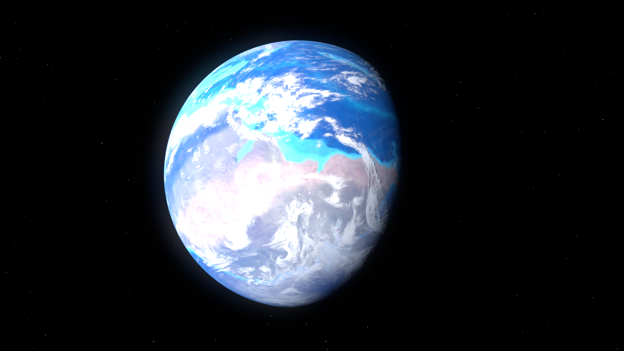
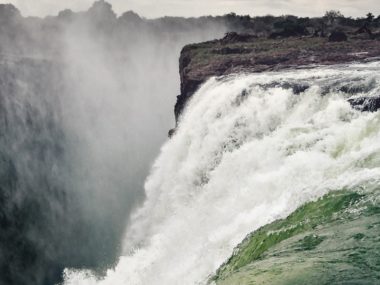
Today, we have seven continents scattered across the globe. North America, South America, Africa, Europe, Asia, Australia, and Antarctica. But once upon a time, did all of these continents link together to form one single supercontinent? We call this theorized supercontinent Pangaea, meaning “all land.”
The views expressed in this article reflect those of the author and not necessarily those of New Creation.
How Do We Know Pangaea Even Existed?
We cannot go back and see what the earth’s surface looked like at any given point of time in history. Instead, we must look at the remaining clues here in the present and make inferences about the past. By combining all of the clues, we can assemble what Earth looked like when Pangaea existed.
Pieces of the Puzzle
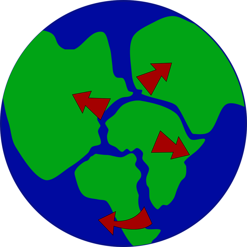
The first clue people noticed is how the outlines of the continents seem to fit together like pieces in a puzzle, especially along the Atlantic Ocean. We see this most easily with the East coast of South America, which just so happens to fit snuggly along the west coast of Africa. Likewise, the eastern coastline of North America and the western coastline Europe fit almost exactly on top of Africa and South America. They fit together like pieces of a really big puzzle.
Perhaps, it should be no surprise that the first person recorded to have noticed this was a geographer. Abraham Ortilius, Catholic geographer and creator of the first modern atlas, proposed in 1596 that the Americas had been “torn away from Europe and Africa…by earthquakes and floods” at some point in the planet’s past. He added, “The vestiges of the rupture reveal themselves, if someone brings forward a map of the world and considers carefully the coasts of the three [continents].”1
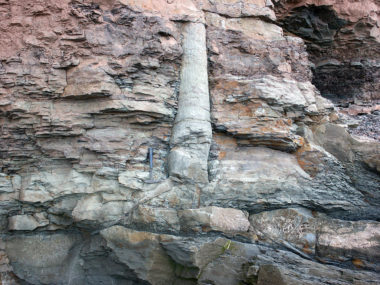
Diamictites
 (Konnarock Formation, Neoproterozoic, ~750 Ma; Rt. 603 roadcut near Konnarock, Virginia, USA) 6, CC BY 2.0, https://commons.wikimedia.org/w/index.php?curid=60350785")
Another clue has to do with diamictites, a type of sedimentary rock composed of non-sorted or poorly sorted particles ranging in size from clay to boulders and suspended in a matrix of mudstone or sandstone. We can trace certain diamictite deposits that formed at the same time across the east coast of South America and the west coast of Africa. Yet, these deposits are absent from the Atlantic Ocean between them. Though generally interpreted as glacial deposits, some geologists have recently argued that they are more consistent with deposits formed by underwater debris flows.2,3 This suggests catastrophic debris flows laid down across South America and Africa before the Atlantic Ocean existed.
Mountains Ranging Around the Globe
 https://www.nature.com/articles/s41598-020-59461-x, CC BY 4.0, https://commons.wikimedia.org/w/index.php?curid=113061005")
Imagine the continents brought back together. The Appalachian Mountains along the eastern coast of North America link up with the Caledonian Mountains of the British Isles and Scandinavia.4 This mountain, too, is absent from the floor of the Atlantic Ocean. This must mean that the mountains existed before the creation of the Atlantic Ocean.
Fossils
 - http://pubs.usgs.gov/gip/dynamic/continents.htmlen:Image:Snider-Pellegrini_Wegener_fossil_map.gif - Original upload 19:49, 13 April 2005 by en:User:SEWilco, Public Domain, https://commons.wikimedia.org/w/index.php?curid=1075951")
Another piece to Pangaea’s puzzle are the fossils of similar or identical types of animals and plants dispersed across multiple continents. Yet we never find these fossils in the ocean floor in between these continents.5 Lystrosaurus is a pig-sized non-mammalian synapsid. We find its fossils in what are today very different parts of the world: India, Antarctica, and South Africa. Fossils of Glossopteris, a type of plant, share much the same range, except we also find it in South America. Fossils of a small, now-extinct, freshwater reptile called Mesosaurus are only found in certain regions of South America and South Africa.
Clearly, these lifeforms did not abruptly appear in all of these same places at the same time. They would have begun in one place before spreading out across their range. While land bridges could explain animals crossing short distances, there is no evidence of land bridges spanning entire oceans. Therefore, this dispersion could only have happened before Pangaea broke apart.
But Do the Continents Really Fit?
Despite the evidence presented above, the scientific community did not immediately embrace the existence. Some critics have pointed out that the edges of modern continents do not precisely interlock when brought together to reconstruct Pangaea.
For example, there is no space for Mexico and Central America to fit in between North America and South America. And North America was rotated clockwise while South America was rotated counterclockwise. Additionally, Africa’s area is actually 35% too large and South America is 20% too small to fit.
The answers to all of these questions came with time. As it happens, the continents themselves have undergone significant changes since their Pangaean days. For example, Central America and much of the western seaboard of North America did not exist until well after Pangaea broke apart. It formed via tectonic activity much later in geologic history.
Pangaea and Young-Earth Creationism
Ever since Christians realized that a supercontinent existed, they have held two main positions on when it divided. The earliest recorded idea suggests Pangaea broke apart in the days of Peleg, one of Noah’s grandchildren living after the Flood. A later idea, most widely accepted today, is that Pangaea broke apart during the global Flood of Noah’s day. Let’s take a closer look at both of these positions.
Pangaea: Divided in the Days of Peleg
Some young-earth geologists propose that Pangaea formed during the Flood and remained intact for some time afterward.6 According to this model, the division of Pangaea took place over a period of at least several hundred years, perhaps during the life of Peleg, one of Noah’s grandchildren. This allowed ample opportunity for animals that survived the Flood aboard the Ark to disperse across the planet without having to cross vast seaways.
We can trace the idea that Pangaea broke apart after the Flood back to 1756. Theodor Christoph Lilienthal, a German professor of Theology at Königsberg, proposed that Genesis 10:25 contains a reference to the break-up of what we would today call Pangaea. It records that “in the days of Peleg, the earth was divided.”7
Most young-earth geologists do not accept this idea today. One reason is that current physics-based models can only demonstrate continental break-up occurring either very rapidly (see below) or at today’s slow and gradual rate. However, the geophysical requirements for moderate continental movement have not yet been modeled. As such, there is no way presently to make the continents move at the speeds required for this model.
Pangaea: Fractured During Noah’s Flood
Today, most young-earth geologists believe that Pangaea was a temporary supercontinent. It formed and broke apart midway during the Flood, perhaps lasting no more than a few weeks.8 During this time, sedimentary layers full of dead plants and animals accumulated across the continents.
According to this model, Pangaea was not the first supercontinent; Pangaea itself formed from the pieces of a previous supercontinent. They believe the first supercontinent formed during Creation Week and broke apart earlier during the Flood. We can trace this idea back to 1858 and a French geographer and scientist named Antonio-Snider Pellegrini. This seems consistent with the form of deep sea crustal movement described in Genesis 7:11 which records the breaking up of the “fountains of the great deep.”
Throughout the duration of its existence, Pangaea was probably mostly or completely covered by water. The water-deposited sandstones formed all around the world at this time provide evidence for this.9 In the 90’s, a team of creation scientists, led by geophysicist Dr. John Baumgardner, developed a model called catastrophic plate tectonics.10 This model explained how the breaking up of Pangaea may have provided a mechanism for how the Flood occurred. Currently, this is the consensus view among young-earth geologists.
Conclusion
There is good evidence that the continents we have today were once joined together to form the supercontinent of Pangaea. By piecing together clues from around the world, geologists have been able to determine what this ancient landmass would have looked like, as well as how and when it may have broken apart.
Footnotes
- Kious, W.J.; Tilling, R.I. (2001) [1996]. “‘Historical perspective’. This Dynamic Earth: the Story of Plate Tectonics” (Online ed.). U.S. Geological Survey. ISBN 0-16-048220-8. Retrieved 29 January 2008.; Ortelius, Thesaurus Geographicus (Antwerp, (Belgium): Officina Plantiniana [Plantin Press] 1596), entry: “Gadiricus.” ↩︎
- Montañez, I. P., & Poulsen, C. J. (2013). “The Late Paleozoic ice age: an evolving paradigm.” Annual Review of Earth and Planetary Sciences, 41, 629-656. ↩︎
- Molén, M. & Smit,J.(2022). “Reconsidering the glaciogenic origin of Gondwana diamictites of the Dwyka Group, South Africa.” Geologos,28(2): 83-113. ↩︎
- Pfeifer, L. S., Soreghan, G. S., Pochat, S., & Van Den Driessche, J. (2021). “Loess in eastern equatorial Pangea archives a dusty atmosphere and possible upland glaciation.” GSA Bulletin, 133(1-2), 379-392. ↩︎
- Paleobiology Database, www.pbdb.org, accessed 31 January 2023. ↩︎
- Dickens, H. 2022. “A Proposed Model For The Drying And Related Stages Of Noah’s Flood.” Origin Research Journal 2, no. 1: 38-64. ↩︎
- Meinhold, G., & Celâl Şengör, A. M. (2019). “A historical account of how continental drift and plate tectonics provided the framework for our current understanding of palaeogeography.” Geological Magazine, 156(2), 182-207. ↩︎
- Andrew A. Snelling, “Noah’s Lost World,” Answers 9, no. 2 (April 1, 2014): 80–85. ↩︎
- Whitmore, J. H. (2019). “Lithostratigraphic Correlation of the Coconino Sandstone and a Global Survey of Permian “Eolian” Sandstones: Implications for Flood Geology.” Answers Research Journal, 12, 275–328. ↩︎
- Austin, S.A., Baumgardner, J.R. Humphreys, R.D., Snelling, A.A., Vardiman, L and Wise, K.P. (1994) “Catastrophic Plate Tectonics: A Global Flood Model of Earth History,” Proceedings of the International Conference on Creationism: Vol. 3, Article 56. ↩︎


good article. yes it makes sense there was av perfwxr single continent on creation week. Then simply during the flood it broke up in order to justify the origin for great surges of water which led to segregated sedimentary creations. A strata. Peleg is only about people and the bible has no interest in geolgy. By the way the single continent must of endured the impacts from space rocks before the flood. Actually the genesis account for Eden suggests the world was different
But how did the continents get such rich animal life? I sat on the edge of my seat for an explanation:)
Sonja, I think one who agrees Earth was at one time one big land mass would probably say, “the animals went with the land they were living on.” For example, the land mass known as Australia today has many different animals, like kangaroos, that live only on its land mass. So when it broke off, you only saw kangaroos on that land mass, now called Australia. And the same can be said about all the other continents. The animals living on the land before it broke off subsequently went with the land mass after the break off. Obviously, similar animals probably lived on more than one land mass….ie, North America and Europe.
I’m not sure I answered your question….I tried. If not, maybe someone else can do better. Cheers.
Nope. After the flood the land creatures left the ark and filled the earth once more. This creationist insists the creatures that went to australia etc are the same creatures as everywhere back in the day. the creatures upon migration needed to change reproductive tactics and so gained what is called marsupial traits. yet they are not related to each other. its just a local condition. if interestede i wrote a easy called “Post Flood Marsupial migration Explained” by robert Byers. Just google.
No creationist I know believes that. The flood fossils in Australia are very different from the few ice age and later marsupial fossils. The flood fossils include platypus variants in what’s now Europe and marsupials in Africa and the Americas. Confusing flood fossils with late ice age and post ice age fossils is a common error. The mammoths etc in Eurasia are ice age. I’ll look at the paper.
After the flood the creatures filled the earth again as God commanded. Yet now in segregated lands but shallow and warm enough to move about. a litttle later the water rised somewhat.
After the flood, the animals left the ark and began to reproduce and migrate. The ice age tied up lots of water in frozen form on land, allowing land bridges to be exposed, on which animals were able to cross to other continents.
There are hundreds of papers on that on creationist sites. When they left the Ark the land animals migrated in all directions. The seas were warm but the land cold, no mature forests yet, so ice sheets formed and sea levels lowered. This allowed some animals to cross into the Americas. The smaller and slower animals today are products of specialization within the kind (baramin) close to family. Some animals may have been transported across gaps by early human hunter gatherers. In some places that’s done today.
Great article. I’ve not spent much time thinking about this, but the concept of a single land mass certainly explains a lot of what we observe.
Check your editing. You have the first reference to the puzzle fitting the ewest coast of South America into the East coast of Africa ….
Check your editing as well brother…ewest coast? 😁
So here is a question. Since all oceans have a bottom, when was there ever a time the land wasn’t connected? Just because something seems like it might fit together doesn’t mean it did. My house and the next door neighbor’s house would probably fit together as well but that doesn’t mean the ground grew up between them. The flood was catastrophic and eroded much land but that doesn’t mean land was totally separated.
Hi Darryl
You are quite correct and stating what should be obvious to anyone with a brain!
During the Upheaval of the Days of Peleg as written at Genesis 10:25 large chunks of seabed sank into the voids th Genesis 7:11 geysers had burst from.
And as some chunks tilted and sank their other sides rose to make the high mountains – that all show many layers of sediments and have seabed shells on their peaks!
Think of how chunks of ice rose, tilted and sank as we jumped on frozen puddles as kids!
I believe the Earth was created with a flexible crust completely covering a subterranean sea. At the Flood (about 3450 BC) close passes of the planet Mars broke up this crust, allowing the subterranean sea to gush forth, covering all the land. An ice moon of Mars, Glacis, shattered, dropping 5 mile deep ice on the two poles. The next year, another close pass of Mars took half the water, so the tops of the mountains appeared for the Ark to land on. Over the next few hundred years, polar ice dropped the sea level further, forming great glaciers over much of the earth (the Ice Age). Then about 2715 BC a close pass of Saturn stole all our liquid surface water and 3/4 of the fractured crust, leaving only Pangea, the polar ice, and a deep chasm. But Saturn also warmed the Earth, causing the glaciers to begin melting. Melt waters pushed the cracked crust of Pangea apart into the continents we now have, and filled the great chasm (now called the Pacific Ocean). Very brief summary – I detail it in my books on my website: GodsPlanOfTheAges.com.
To people looking for a scientific explanation I suggest Kurt Wise’s presentation “In-depth Explanation of What Caused Noah’s Flood – Dr. Kurt Wise” on YouTube.
Great article, one I will share with my children! One correction that should be made — “east coast” of South America and “west coast” of Africa fit together.
good article, makes sense. perhaps there was only one continent that broke up after the flood, the waters bursting forth could have started the split, & the receding waters finished it, but weren’t completely receded until Peleg. That would explain the commonality of the flood story to many parts of the world. I do have a question about one sentence that doesn’t seem finished: “The answers to all of these questions came with time. As it happens, Mexico and Central America did not exist until after Pangaea broke apart. They and the rest of the western edge of North America are ” They and the rest of the western edge of North America are…. what? what are they?
I would think a few comments about the mid-Atlantic Ridge would be in order.
There’s a sentence (or more) missing in the section called “But Do the Continents Really Fit?” Is it possible to have this corrected?
In your 3rd paragraph you made an obvious mistake – “the west coast of South America, which just so happens to fit snuggly along the east coast of Africa.”
You have your east and west backwards.
Thanks Christian! glad to get a refresher on this as musical person who doesn’t engage science as much.
Christian,
Great article. I have some questions for you at the same time. You say “Therefore, this dispersion could only have happened before Pangaea broke apart.”
This dispersion would have been from Noah’s Ark.
This would be an argument for separation of the continents in the days of Peleg – correct?
But then you seem to align yourself with Catastrophic Plate Tectonics (CPT) later in the article. This CPT has the separation of the continents at the later part of Noah’s worldwide flood. Which do you believe?
I would suggest an alternate to CPT. That alternative that aligns with continental separation hundreds of years after Noah’s worldwide flood is Shock Dynamics. The explanation of how an asteroid split the continents – and the evidence to support such is at “newgeology.us”
Since the asteroid (bigger than chicxulub) hit on the East coast of Africa the continents slid away – forming the ring of fire on the leading edges of those continents.
Yes and No to Pangea.
The Bible clearly says Earth had one 90% landmass with two rivers pouring into one small sea.
During the Uphevals of Pelegs Day the crust already weakened during The Flood both collapsed in place and rose in others. This happened quickly as proven by the closed seashells on mountain tops.
Hello, Pangaea sounds real and all, but was it really there? It kind of feels as if it wasn’t real and it was just like how it is now.
Europe is one of today’s continents too.
I always imagined Pangaea was separated when God separated the nations after the Tower of Babel. I’ve never researched this, but it’s always made sense to my mind. Has this been considered as an option?
No Peleg would have been Babel only, division of people, a scattering so they survive the ice age, and the whole of continental drift was a flood event, The flood event. All the fossils are either from the flood or from the end of the ice age 400 to 600 years later after the flood. Babel is in the middle of the gap between the flood and the start of the ice age. https://creation.com/ has dozen papers and books on that as does https://answersingenesis.org/ and here at new creation there will be similar papers. They are just getting started.
In my view (ever since I saw a map that removed the ice and applied sea level across the map) Antarctica is not really a continent. It is an archipelago covered in ice.
Has any work been done with the new discovery of massive oceans of water that have been discovered recently under the earth? Do these have any indications or inferences on pangea or the flood?
What is the evidence that Pangaea was not the first super continent and only temporarily created during the flood, rather than Pangea being the only supercontinent made during creation week and then breaking up during the flood?
One thing in all this which appears to be overlooked is, where did all the sediments that are now on the continents come from? And…how did the come to be in the rough order vertically they have…marine critters/shellfish on the lower layers? Frankly it seems to me the preflood oceans and continents have been reversed. When erosion occurs, the trajectory is downhill. If the preflood continents were eroded the debris/sediments would run off the continents into the oceans and be deposited there, with ocean dwellers being buried first. Then, with the continents eroded perhaps down to bedrock and the oceans now filled with thousands of metres of sediment, the preflood continents sank down to form the present oceans with little sediment in them, and the preflood oceans were raised to form the present continents covered with thousands of metres of sediments. With the uplift of the preflood oceans, secondary erosion would erode and shape the new uplifting continents and deposit the sediments into the new oceans.
Actually there are major places where the order is inverted of mixed but they will not tell you that at school or university. John Woodmorrappe has a book mapping the.
However if you have a flood and sedimentation of any kind you get fish first then land flora and fauna as a simple consequence of the process. The fact that its inverted in some places tells us that its a catastrophe. The sediments came from the preflood continent, volcanic activity and huge hydrothermal chemical/ mineral releases. It’s not on the ocean floor because at certain depths sand, clay and some rocks dissolve into solution and re-deposit as beaches. Whether your a creationist or an evolutionist that last point is not disputed.
I love to speculate what a map of the preflood world looked like. Where Eden was, the land of Nod, the city of Enoch. Not to be know until Heaven I guess.
Robert Mihin has a book – Genesis Modeled: The Catastrophic Case for a Young Earth, which should be published in November.To learn more and to be notified when the book is published, go to “theyoungearth.com.”
As far as answering the question: How did the animals get from Noah’s ark to the separated continents after the Flood?, Mihin says that people built ships to sail the seas, and took animals with them.
I think that when Pangea broke apart, hot molten magma from the mantle flowed up into the rift of the mid-ocean ridges. Ocean water over the magma was boiled and steam shot up into the upper troposphere where the steam condensed and created torrential rain for 40 days and nights. Sulfur dioxide (SO2) from the volcanic eruptions along the mid-ocean ridges also was carried up into the troposphere. Since SO2 is heavier than steam (H20), the steam rose higher than the SO2. SO2 reflects heat so the heat from the steam condensing was lost to space, and the solar infiltration was also reduced by the SO2. This solves the excess heat problem from the new ocean floor and also from accelerated nuclear decay. Mihin will go into much greater detail in his book.
Greetings from Downunder. Thank you, a great article.
Probably indirectly related to Pangea, is the shallow body of water that exists between Australia mainland and Tasmania, known as Bass Strait. Its depth averages about 50 metres and and it is dotted with many islands on the eastern side of the strait. Known to be notorious by mariners due to its shallowness and surrounded by the Continental Shelf causing huge steep and short seas, old earth theorists suggest it sank about 12,000 years ago.
I am surprised the author didn’t quote Genesis 1:9, 10, which surely indicates that in the Creation week God made one ocean and therefore one landmass: “(9) And God said, Let the waters under the heaven be gathered together unto one place, and let the dry land appear: and it was so. (10) And God called the dry land Earth; and the gathering together of the waters called he Seas: and God saw that it was good.”
Seems a very one-dimensional view for it means there was “NO LAND AT ALL ON 3/4 of the rest of the Earth”…?!
How does that make any sense = think about it…!!!
Love and appriciate your groundbreaking work on bringing true science into the modern discussion of how we came to be. Here in secularised Sweden the information you present is very helpful in witnessing and sowing seeds of faith in the true Creator of life, our precious and only worthy, the Lord Yeshua and his Father and Holy Spirit
My question is a theory I’ve held for a while. If there’s evidence against it, I’d like to know. But during the days when people lived longer, could it not have been that the days were shorter? Could it not have been that the days were shorter because the earth was traveling around the sun faster? Could the sun not have traveled faster because it was smaller and more dense? After the flood, and the pent up waters were out on the surface, could there not have been tension on the land due to the difference in size? During the days of Peleg, when the earth was divided, could it not have separated then? I understand what the writer of the article said about the land division being during the flood. I’m not really saying anything against that. I’m not set on one way or another. Just…could it not have been this way and because of this? Also, with the earth being bigger and less dense, the earth could have slowed its rotation and revolution, resulting in longer days and years, and ultimately resulting in people living for a shorter amount of time. (I’m not online much due to a sensitivity to EMFs.)
No that does not work. Orbital mechanics defines the year and neither the earth or sun can change that fast or that much. We also have someone having a child at 7 years of age if you compress the years into quarters or months. DNA was better, undamaged by mutation so they lived much longer. Peleg was Babel dispersion caused by God, people spreading out because if they stayed at Babel they would have starved in the ice age.
Thank you.
Yes but its not the pre flood continent. The plate boundaries and fold mountains, Urals, etc that form Pangea are rich with fossils so the pre flood continent must be Rodinia. There is a pseudo super continent between, Pannotia, but its two masses clipping at one point and that to has some fossils and oil. It has to be Rodinia at the start of the flood. Pangea is a mid flood continental layout.
I am very glad to see someone in the Christian community address the issue of the possibility of a single continent in the earth’s distant past. Thank you, Christian Ryan.
I have taught physical science and life science online for Moody Bible Institute for the past 17 years, and our current text addresses Pangea in the Physical Science readings. One person I am interested in is Alfred Wegener, the German meteorologist. He suggested the possibility of a single land mass in the distant past, with movement into the present continents by way of continental drift. (see The Sciences: an integrated approach, by James Trefil and Robert Hazen, published by Wiley in 2016, pp.381-387) Wegener, simply had noticed and catalogued a number of similarities of organic and geological nature among the continents in 1912. He did not, however, suggest a mechanism for the continental drift to take place, and because his suggestion was so far out of the traditional scientific training of most geologists and geographers, his ideas were rejected outright! It is interesting to me that Wegener was simply interested in these similarities among the continents from a meteorological viewpoint. Yet, his ideas were vindicated by discoveries made through the 1950’s and 60’s during an international effort to map the ocean floors. I’m giving a very abbreviated account here, for the sake of this merely being a comment to Christian Ryan’s article.
I hope Christian will continue his interests in this area, and I look forward to reading any more articles on this later.